| Battle of Hastings 1066AD - G - New Romney Destroyed |
|---|
|
| Introduction ▲ |
|---|
After the Battle of Hastings, with Harold dead and England effectively won, William the Conqueror did something that the chronicles record but historians have never fully explained. Before marching on London, he turned east and visited a coastal settlement on the Romney Marsh.
Master Wace says some of his men had arrived there by accident and been killed by the locals. Orderic Vitalis says they had landed in error and been routed. Both record William's response as deliberate and severe. Archaeologists working in New Romney have since found a late 11th century fire layer, though whether this was William's doing or accidental cannot be confirmed.
The standard explanation — that a handful of ships simply got lost — is difficult to accept at face value. A fleet of nearly 700 vessels sailing together does not easily send ships to the wrong coast by mistake. This page examines what the chronicles actually say, what we know of the Romney area in 1066, and whether the answer might lie not in the crossing itself but in the storm that damaged the fleet weeks earlier at Dives.
One possibility is that ships overloaded as a consequence of those storm losses struggled on the crossing and made for the nearest shore. Another is that William had arranged for distressed vessels to make for Winchelsea, and some reached the wrong port. The evidence does not allow certainty. What it does allow is a more considered reading of why William reacted as he did — and why the Romney people may have responded the way they did to unexpected armed arrivals on their shore.
| Documentary evidence ▲ |
|---|
Master Wace
The Duke placed a guard in Hastings, from the best of his knights, so as to garrison the castle well, and went thence to Romenel, to destroy it utterly, because some of his people had arrived there , I know not by what accident, and the false and traitorous had killed them by felony. On that account he was very wroth against them and grievously punished them for it.
Orderic Vitalis
When his own dead had been given honorable burial he advanced to Romney, defeated the garrison and avenged the slaughter of some of his men. They had landed there in error and had been routed in the ensuing battle by the fierce defenders, with terrible losses on both sides.
| 
| | |
|---|
What we know of the area ▲ |
|---|
The name Romney is derived from the Saxon 'rom' meaning a ram and 'ney' derived from 'en æg' - en - people of and æg - an island - so 'the island of the ram people'.
The first written reference to Romney is dated 740AD in a grant of King Ethelbert which mentions the chapel of St. Martin being located here. Sometime before this the Rother/Limen changed its course from where it originally reached the sea at Hythe and broke through to the sea at ‘Old’ Romney.
Anglo Saxon Chronicle mentions
A.D. 893.
This year went the large army, that we before spoke about, back from the eastern district westward to Bologne; and there were shipped; so that they transported themselves over at one time with their horses withal. And they came up with two hundred and fifty ships into the mouth of the Limne, which is in East-Kent, at the east end of the vast wood that we call Andred. On this river they towed up their ships as far as the weald, four miles from the mouth outwards; and there destroyed a fort within the fen, whereon sat a few churls, and which was hastily wrought.
A.D. 894.
Hasten was there with his gang, who before were stationed at Milton, and also the main army had come thither, that sat before in the mouth of the Limne at Appledore.
Post 900AD New Romney and the Langport
The Vikings had left but the slow moving Rother continued silting up the area around Old Romney, and the port had to be moved to modern New Romney in the late 900's AD, where it was known as Langport.
The Domesday Book
only shows one entry for Romney with a tiny population and no damage, there is no mention of Langport, however the Normans created the Rape of Langport, and not the Rape of Romney. This means its likely that the Chroniclers were referring to the 'area of Romney' when they mention Romenel and not the settlement. This in turn means that the Langport was the place that was destroyed and not Old Romney.
| An Interpretation of the Chronicles ▲ |
|---|
Some of the Norman vessels landed on the Romney marsh probably near to Langport, the only logical explanation is that these vessels were overloaded, or were taking on water and the nearest land was the Romney area.
The locals wouldn't have taken kindly to this as they had been supporters of Earl Godwin in the early 1050's, unlike nearby Hastings who seemed to support the King and his Norman influence.
A thought:
If Fecamp controlled Winchelsea further along the coast it is possible that William had said that ships having issues should land there, but some by mistake landed at the wrong port.
| Archaeology ▲ |
|---|
Evidence of Fire: Excavations in New Romney—including those conducted by the Kent Archaeological Society in the 1960s and 70s—uncovered layers of destruction from the late 11th century, including charred timber and ash.
Possible Causes: This fire might be linked to William the Conqueror's punitive campaign, such as the destruction of Langport. However, accidental causes cannot be ruled out. Given that buildings in New Romney were primarily timber-framed and sealed with flammable tar or resin (a common waterproofing method against Channel storms), the town would have been highly vulnerable to fire. Combined with the area’s typically strong winds, even a small blaze could have spread rapidly—whether by accident or design.
| Conclusion ▲ |
|---|
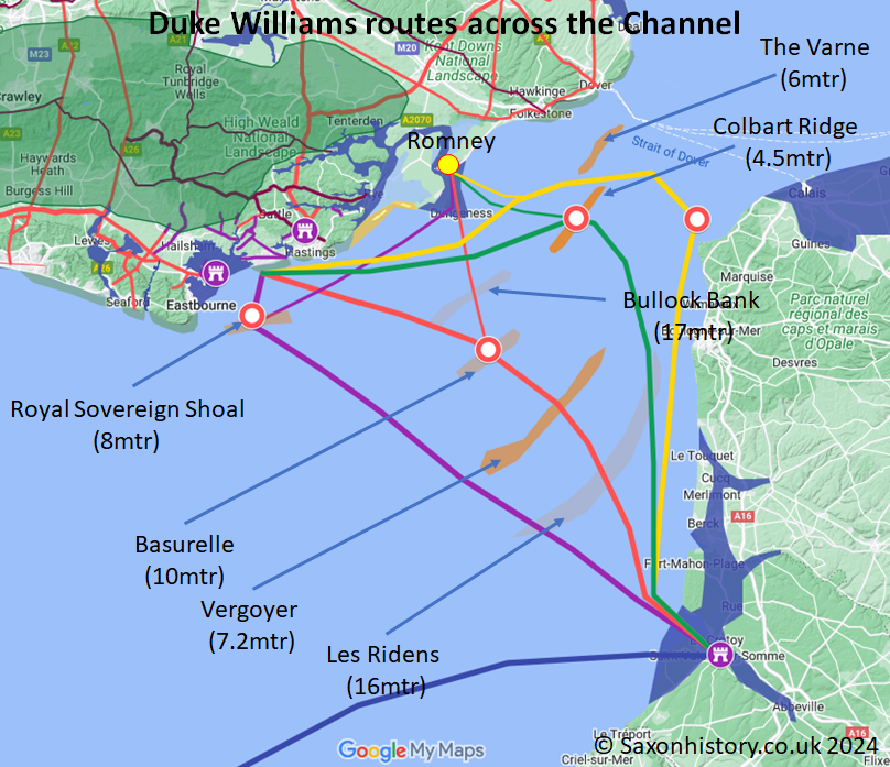
It seems unlikely they would have landed in Romney by error as 700 ships were sailing together, it is much more likely that the vessels were taking on water and they needed to reach the nearest shore, and if the route went from the Colbart Ridge to Pevensey, then Romney would have been the nearest shore line.
"The most likely explanation is that the 83 knarr lost in the Channel storm between Dives and St Valerie forced the remaining vessels to carry extra cargo — see Page 'Battle of Hastings 1066AD - I -Duke William' for the full logistics calculation."
|
|
|
|
;)


