| Battle of Hastings 1066AD - L - The Landing , where was it ? |
|---|
| Table of Contents |
|---|
| Introduction ▲ |
|---|
Where exactly did Duke William land his invasion fleet in September 1066? The chronicles tell us "Pevensey" — but Pevensey was a Roman fort, a name applied to a wide stretch of coastline, not a single pinpoint on a map. When you factor in 694 ships, 3,000 horses, nearly 13,000 people, and the physical reality of the 1066 coastline, the question becomes far more complex and far more interesting than it first appears.
This page works through every proposed landing site systematically — from Pevensey Castle itself to the Brede valley — testing each against a consistent set of criteria drawn from the chronicles, the Domesday evidence, the landscape reconstruction, and some basic geometry. How much coastline do 694 ships actually need? Which stretch of shore fits the Carmen's description of a "sheltered arc of strand"? Where does the pattern of wasted and undamaged Domesday villages point? And what does the destruction of two Norman ships at New Romney tell us about the route the main fleet did not take?
The answers, taken together, narrow the landing to a surprisingly specific stretch of coast.
| | |
|---|
Map of the Hastings area in 1066AD ▲ |
|---|
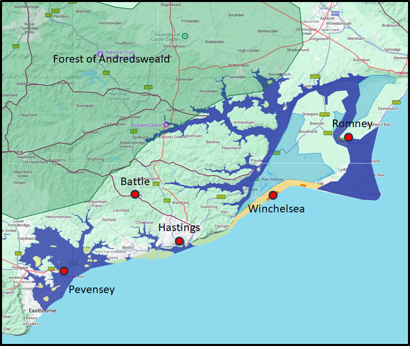
This is my latest map showing the landscape of the Hastings area in 1066.
(Created using Google My Maps.) |
|---|
In this map the following assumptions have been made:
The high tide levels shown are at a high tide mark of 4.5 metres higher than at present.
The Variable Ocean: Was the high tide level in Saxon times at Pevensey at about 4.5 metres ?
The Variable Ocean: Was the high tide level in Saxon times in the Wash 4 to 5 metres higher ?
~~Sea_Level_Rises~~
The Great Oak Forest of Andredsweald is shown.
Anglo Saxon Chronicles - 892AD - The Great Oak Forest of Andredsweald
The location of Old Winchelsea is shown on its shingle bank.
Landscape - Old Winchelsea an elegant explanation
The shape of the land near Hastings in 1066AD including coastal erosion.
Battle of Hastings 1066AD - J - Landscape of Haestingaport
The Romney Marsh in 1066AD, the river Rother has changed its course through time.
Landscape - The History of the Romney Marsh in maps
Fécamp Abbey influence
Battle of Hastings 1066AD - K - Hastings and its links to Fécamp Abbey
New Romney and its destruction
Battle of Hastings 1066AD - G - New Romney Destroyed
| Documentary Evidence from the Chronicles ▲ |
|---|
Anglo Saxon Chronicles
Meantime Earl William came up from Normandy into Pevensey on the eve of St. Michael's mass; and soon after his landing was effected, they constructed a castle at the port of Hastings.
Battle Abbey Chronicles
The duke, therefore, with a prodigious army, and attended by the divine favour, arrived safely near the castle called Pevensey. The soldiers leaped joyfully upon English ground at intervals along the shore.
It happened as the duke left his ship, that he fell upon his face, making his nose somewhat bloody upon the beach, and grasping the earth with his outstretched hands.
Many of the bystanders feared the consequences of so unlucky a presage, and stood whispering together. But the duke's ewer, William Eitz-Osbert, a man of great merit and much ready wit, being at hand, boldly rallied the failing courage of the waverers with a word. 'Cease men,' said he, 'to interpret this as a misfortune, for by my troth, it is a token of prosperity ; for lo ! he hath embraced England with both his hands, and sealed it to his posterity with his own blood ; and thus by the foreshowing of Divine Providence is he destined effectually to win it !'
Bayeux_Tapestry
Troops disembark and are sent to Hastings to get provisions.
hic exeunt caballi de navibus et hic milites festinaverunt haestinga ut cibum raperentur
(the horses are taken from the ships and the soldiers make haste to Hastings to seize food)
|
Carmen de Triumpho Normannico
Nor fear the Northern gale, but to a charming landing place
Nor the rocky coast looming perilous
The third hour of the day overspread the earth
Since leaving the sea behind when you seize a sheltered strand
The land belonging to you had been stripped of tenants
You rejoice as you and yours seize a peaceful arc of strand
You secure the bridgehead fearing to neglect the ships
And raise palisades, that you may site the camp within
You restore the forts that were long since destroyed
You station garrisons that they may be defended
Not much space has been occupied by your men in peace
Florence of Worcester
While these events were passing, and when the king might have supposed that all his enemies were quelled, he received intelligence of the arrival of William, earl of Normandy, with an innumerable host of horsemen, slingers, archers, and foot soldiers, having taken into his pay auxiliary forces of great bravery from all parts of France ; and that he had moored his fleet at a place called Pevensey.
Henry of Huntingdon
No reference to this subject in this document.
Master Wace
The ships steered to one port; all arrived and reached the shore together ; together cast anchor, and ran on dry land ; and together they discharged themselves.
They arrived near Hastings, and there each ship ranged by the other's side. There you might see the good sailors, the Serjeants and squires sally forth and unload the ships ; cast the anchors, haul the ropes, bear out shields and saddles, and land the warhorses and palfreys.
The archers came forth, and touched land the foremost; each with his bow bent, and his quiver full of arrows slung at his side. All were shaven and shorn, and all clad in short garments, ready to attack, to shoot, to wheel about and skirmish. All stood well equipped, and of good courage for the fight ; and they scoured the whole shore, but found not an armed man there.
After the archers had thus gone forth, the knights landed next, all armed; with their hauberks on, their shields slung at their necks, and their helmets laced. They formed together on the shore, each armed up on his warhorse. All had their swords girded on, and passed into the plain with their lances raised.
William of Jumièges – Gesta Normannorum Ducum
The Duke, with God prospering him, directed his fleet toward the land of the English and, carried by a favorable wind, reached Pevensey within a few days. There, having disembarked his army, he ordered a fort to be built.
Orderic Vitalis – Gesta Normannorum Ducum
When at last by the grace of God the favourable wind sprang up in answer to so may prayers, the Duke impatient to set out, called all of his men forthwith to the ships and commanded them to set sail with courage. So the Norman army crossed the sea on 29th September, the night where the universal church celebrates the feast of St Michael the archangel, and reaching the coast of England, where they met no opposition, gladly came ashore. They took possession of Pevensey and Hastings and gave them into the charge of chosen soldiers as a base for the army and shelter for the fleet.
William of Poitiers – Gesta Guillelmi
The vast fleet, which had assembled at Dives and Saint-Valery, awaited the wind... At last, with divine mercy sending the wind, they entered the sea and reached England. They landed at Pevensey, where the soldiers immediately disembarked and began to secure the place. The English, seeing the Normans’ ships, were terrified and took flight. The Duke, being a man of great wisdom, ordered a fort to be built there.
William of Malmesbury
No reference to this subject in this document.
Quedam Exceptiones de Historia Normannorum et Anglorum
Everything having been prepared, he set forth for England together with his fleet, propelled by a steadily blowing following wind, and landed at Peneuesel, where at once he restored the most strongly entrenched fortification and, entrusting it to his soldiers, he went to Hastings and there established another fortification.
| Landscape Overview ▲ |
|---|
The first thing to note is that there were and still are cliffs to the west of Eastbourne
and also between Hastings and present day Fairlight.
The cliffs are mentioned in the The Carmen de Triumpho
Normannico(Carmen)
'Nor the rocky coast looming perilous'
'One Englishman kept hidden under the sea cliffs'.
If this is true then we can deduce that the fleet went past some cliffs on the way to the landing spot.
If the fleet sailed from the direction of St Valerie then they would have been very unlikely to sail past Beachy Head and the cliff off the coast at Eastbourne.
Hence the only logical cliffs that could be sailed past were the ones between Fairlight and Bulverhythe.
There are also references in the Carmen to 'Since leaving the sea behind when you seize a sheltered strand' also
'I rejoice as you and yours seize a peaceful arc of strand' and 'And so carried with him, returned to his seaside camp'.
So this would imply a sheltered or protected not too hilly seaside landing place. If we also assume that there were about
700 Norman ships which when landing they would occupy about 6 metres per ship this would mean the landing site would need
to be about 4200 metres wide, so about 2 1/2 miles from one end to the other .
There are also references to the location in the 'Gesta Normannorum Ducum(Gesta)'
'and crossing the sea he landed at Pevensey where he immediately built a castle with a strong rampart'.
and
'He left this in charge of some troops, and with others he hurried to Hastings where he erected another similar fortress'
We also seem to have a reference to the ships sailing towards the West as a vessel appeared to land at New Romney
where the Normans were killed, as William attacked New Romney on his way to Dover(This could only have been by sea
as the marshes did not really support marching). This implies that the Normans were sailing towards the west and passed
the Romney marsh on the way to their landing at Pevensey(Cooden).
| Referenced items that effect the Landing Location ▲ |
|---|
Anglo Saxon Chronicles - 'into Pevensey on the eve of St. Michael's mass; and soon after his landing was effected, they constructed a castle at the port of Hastings'
Battle Abbey Chronicles - 'arrived safely near the castle called Pevensey'
Bayeux Tapestry - 'William sails to Pevensey' and 'He lands at Pevensey'..
Carmen de Triumpho Normannico - 'leaving the sea behind when you seize a sheltered strand'
Florence of Worcester - 'he had moored his fleet at a place called Pevensey'
Master Wace - The ships steered to one port' and 'They arrived near Hastings'
William of Jumièges - 'reached Pevensey within a few days'
Orderic Vitalis - 'They took possession of Pevensey and Hastings '
William of Poitiers - 'They landed at Pevensey, where the soldiers immediately disembarked and began to secure the place'
Quedam Exceptiones de Historia Normannorum et Anglorum - 'and landed at Peneuesel, where at once he restored the most strongly entrenched fortification and, entrusting it to his soldiers, he went to Hastings and there established another fortification. '
So to condense all requirements for the location we come to the following possibilities:-
- Near Pevensey or Pevensey Bay and near Hastings
- Went past a rocky coastline
- In a sheltered landing place
- Create a moated fort(flat pack)
- Visible from a high hill or cliff
- Near to the wasted or damaged villages in the Domesday book
- Within horse riding distance of Hastings
- You restore forts long since destroyed
| How much space would 694 ships need to land side by side ▲ |
|---|
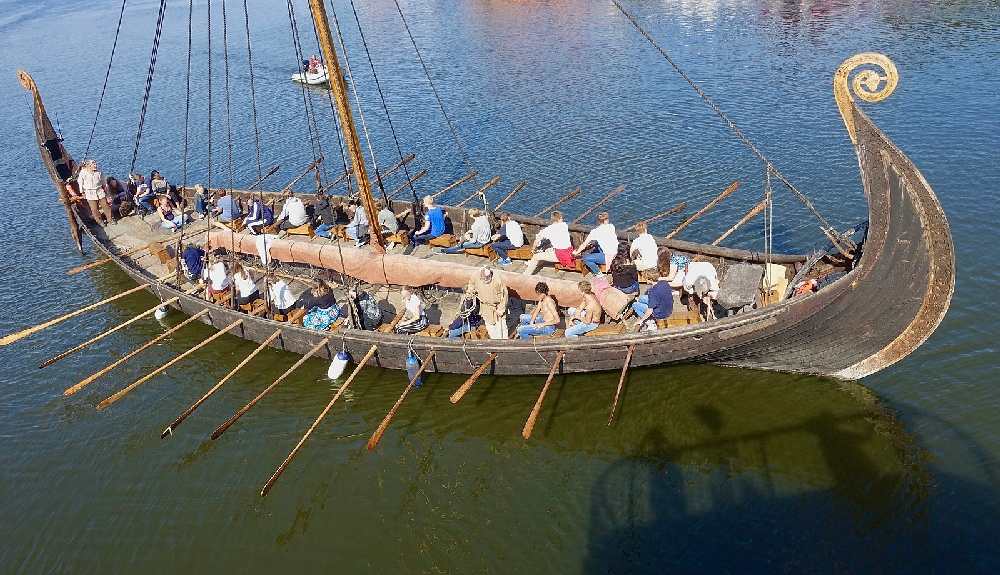
This image of a Viking longboat is from https://www.thildekoldholdt.com/post/viking-age-ships, and shows that they were able to carry large numbers of people possibly 50 or 60 if just used for transport.
The Ship list of William counts the number of vessels at 770 probably on leaving Dives, Master Wace suggests 694 on leaving St Valerie so we will use that figure.
The ships we are talking about were most likely Viking long-ships so we should allow about 5 metres for the width of the vessel. (Battle of Hastings 1066AD - C - Ships - Drekka, Snekkja and Knarr)
The Oseberg ship, a Karve, was 5.10 meters (16.7 feet) wide.
The Gokstad ship was 5 meters (16 feet) wide
If we then allow for the oars then we have to allow a further 2.5 metres per side hence we come to about 10 metres as a total width.
We then need to leave space between the vessels so lets add a further 3 metres to the width which means we are at 13 metres total width.
The summary below shows how much landing space is required for 694 ships:
Just the 5 metres for the width of the vessels = 3,475 metres = 3.5Km (2.1 miles)
Width of vessel plus oars at 10 metres = 6,950 metres = 6.9 Km (4.2 miles)
Width of vessel plus oars plus space at 13 metres = 9.035 metres = 9.03Km (5.6 miles)
This is a significant width of space for the landing and would mean that the whole coastline from Cooden to Hastings would be taken up.
Note:
This is calculated for Viking longships, if you look at the transport ships, these were about 7 metres wide so would take up even more space.
| Where were the Damaged/Destroyed villages from Domesday ? ▲ |
|---|
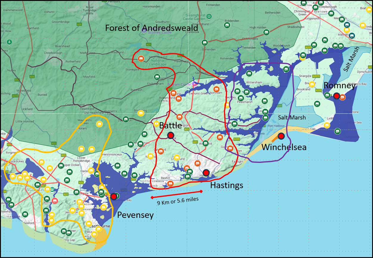
| The Domesday villages around the Hastings area 1066AD (made using Google My Maps) |
This map shows the location of all the villages recorded in the Domesday Book 1086AD
The area surrounded by red shows those villages that were wasted according to Domesday, these seem to start from the coast at Bexhill, this also appears to imply that the Normans were aware of the road network.
The area surrounded by yellow shows those villages that were damaged according to Domesday, these were mostly near to Pevensey Castle, with a few near Bexhill.
The area surrounded by purple shows the land that had been given to Fecamp abbey before the invasion.
Villages shown in red were those recorded as wasted.
Villages shown in yellow were recorded as being damaged.
Villages shown in green were recorded as not damaged.
The map also shows a line of 9 Km or 5.6 miles which is the length of coastline that 694 ships would take up when landed side by side.
Domesday anomalies:
The modern town of Battle was only settled after the battle when the Monks built the Abbey, and it is the only place in the area whose name is not a Saxon derived name. It is named after the French 'la Bataille' - the battlefield.
Hastings is not recorded anywhere in Domesday, even though we know it was a major port prior to the invasion. (could this be because the people of Hastings invited William in ? - we shall never know)
Winchelsea is also not recorded in Domesday, even though it was also a major port, but the estate of Rameslie was owned by the Norman Abbey of Fécamp, and had been since 1017AD. (Battle of Hastings 1066AD - K - Hastings and its links to Fécamp Abbey)
| Proposed Landing places ▲ |
|---|
As you can see in the next map there are a large number of damaged villages near to Pevensey, implying that the Normans took the fort and carried out raids mostly towards the west, so probably had cavalry based in the old Roman fort of Anderida, which was owned by the Godwin family prior to the invasion.
In the Bexhill and Hastings area we can see a few villages in the Filsham valley that were untouched, but a large majority of villages north of Hastings and Bexhill were wasted or damaged, implying that the Normans again knew the landscape.
The villages in the Winchelsea, Rye area appear untouched, this is probably due to the influence of the Abbey of Fécamp in the area.
Between the damage centered on Pevensey and the Bexhill/Hastings cluster there are a number of other undamaged villages near modern Ashburnham, there is a possibility that this was a shipbuilding area that William did not want damaged, or just that they were not on the main roads.
You can also see that some of these villages are within the area of Andredsweald implying that the Normans knew the area, roads and ridgeways before Harold arrived for the battle.
A great number of arguments for the site of the Norman landing have taken place, this is the list of locations that have been proposed:
- Pevensey Castle
- The Hooe Peninsular
- The bay north of Barnhorne
- The Cooden area
- Bexhill
- Bulverhythe / Filsham valley
- Hastings
- The river Brede valley
| 
| 1. Landing at Pevensey Castle ▲ |
|---|
The Pevensey area was a protected bay, with the Downs reaching the sea near Beachy Head, this was about 0.8 Km further out in Norman times, and appeared to have a large beachy area to the East of the cliffs.
If this was the only landing place then finding a good route across the marshes to get to Hastings would have been difficult to find but the knights are shown riding in the Bayeux Tapestry. William would have left the area via Lewes as that was the easiest route to get out of the area due to the Roman Road layout and he would never have gotten to Hastings.
-
 Went past a rocky coastline - Cliffs at Hastings Went past a rocky coastline - Cliffs at Hastings
- In a sheltered landing place
 Create a moated fort(flat pack) - unnecessary Create a moated fort(flat pack) - unnecessary- Visible from a high hill or cliff - Overlooked by Beachy Head and the cliffs at Hastings
- Near to the wasted villages in the Domesday book
- Within horse riding distance of Hastings - Route is very difficult
- You restore forts long since destroyed - one of the forts
There was a large amount of damage to the local villages, so the Normans must have been here . Therefore the logical conclusion is that William landed here to take over the Castle, then once it was secure and repairs made and troops occupying he took the rest of the fleet and sailed back towards Hastings. The garrison then continued to raid the area.
| 2. Landing on the Hooe Peninsular ▲ |
|---|
The next place is the Hooe Peninisular as its protected by Beachy Head, again this is possible but is not really overlooked by
the Cliffs at Eastbourne, and again the damage to the villages seems to be less intense as those locations further east.
- Went past a rocky coastline - Between Eastbourne and Hastings cliffs
- In a sheltered landing place
- Create a moated fort(flat pack) - no evidence
- Visible from a high hill or cliff - Passed by Fairlight
- Near to the wasted villages in the Domesday book
- Within horse riding distance of Hastings
- You restore forts long since destroyed - no evidence
If this was the location then William would have left the area via current day Ninfield to join the old ridgeway at
the modern day A271/B2096 junction as that would be the easiest route to get out
of the area due to the Roman Road layout and from here could ride to Hastings.
Due to the distance away from the wasted villages and no evidence of forts, it would seem that this site is difficult to match with all the documentation.
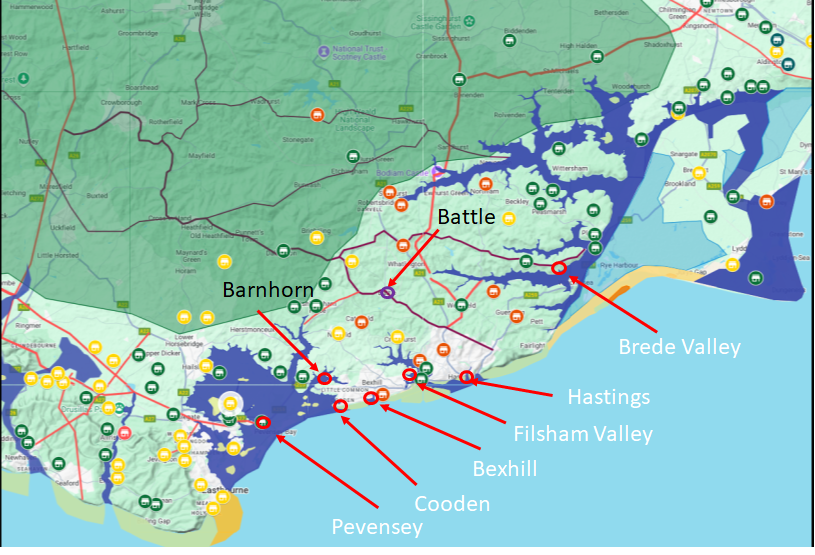
| A map of the coastline at Hastings in 1066AD ▲ |
|---|
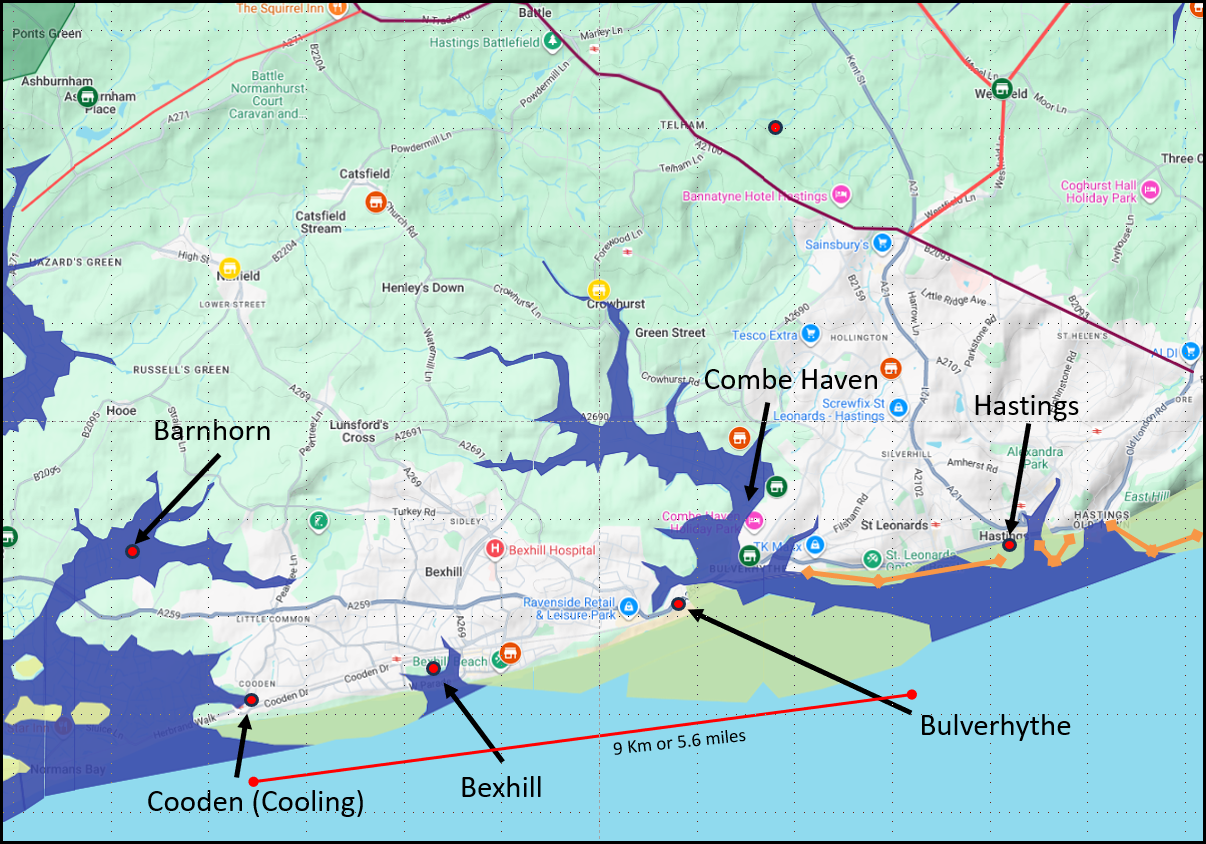
This map shows the coastline from Hooe to the Fairlight Cliffs this includes the Barnhorne inlet, Cooden, Bexhill, Bulverhythe, the Combe Valley and Hastings.
The orange lines show the areas where it is likely that cliffs were, making them difficult to land.
The map also shows a line of 9 Km or 5.6 miles which is the length of coastline that 694 ships would take up when landed side by side. - please Note that transport ships may have been even wider so the ratio of transports to longships would change this.
The high tide level is shown at about 4 metres higher than present, please see the following pages for an explanation.
The Variable Ocean: Was the high tide level in Saxon times at Pevensey at about 4.5 metres ?
The course of the river Asten that flows through the Combe Haven and the eroded land south of Bulverhythe is explained on the following page.
Battle of Hastings 1066AD - J - Landscape of Haestingaport
Lets look at the meaning of the locations shown in case this helps.
Barnhorn - barn derived from beorn - burn,fire or light horne derived from horn - a horn-shaped projection.
(As you can see Barnhorn is a promontory and it appears like an animal horn i it was possibly a Roman signalling point during Carausius reign.)
Cooden (originally Cooling) - derived from cæle ænge - originally Cooling which derives from cæle - a ships keel - ænge meaning troubled village(appear to be fortlets or pallisaded villages).
(So this area was probably a small shipyard)
Bexhill - bex derived from buxus - box trees hill derived from hyll - a hill.
(The hill where the box trees grow and the coastal area appears to be a small protected harbour)
Bulverhythe - bulver derived from burgh wær - beorg - a high place - hill
wær - the sea and hythe derived from hyð - hythe - usually a harbour or port, an important or first one, or starting point of a tribe.
(My Interpretation - The high place on the coast where the Haestingas landed)
Combe Haven - combe derived from comb - A low place enclosed with hills, a valley or haven derived from haefen - a haven - a protected port.
(My Interpretation - The place where the ships of Hastings were taken for protection in a storm)
Hastings - hast derived from haeste/hasta - in saxon a storm, or wild sea /in latin(roman) it is the generic name for spears and ings derived from ænge - troubled village(appear to be fortlets or pallisaded villages).
(My Interpretation - The wild sea fort or the spear fort)
| 3. Landing in the bay north of Barnhorn ▲ |
|---|
The next place to the East is Normans Bay - Barnhorne(Normans Bay is modern and Barnhorne Saxon) this is a
possibility as its overlooked by the cliffs at Eastbourne, but the wasted villages all seem to be
further East, but this may be due to limited local population.
Near the local area is a moated location at Cooden
which could have been built in this time as its known it was in use in the 13th century, only a few
years after the landing, and is likely that the local de Codlinge family just took over the 'flat pack' fort
after the invasion.
Also after plotting in detail the 5 metre contour line it would seem that there was
land protecting this estuary from the worst of the Channel weather by the ridge at Barnhorne,
so was a protected harbour.
- Went past a rocky coastline - Hastings cliffs
- In a sheltered landing place
- Create a moated fort(flat pack) - small fort at Cooden
- Visible from a high hill or cliff - overseen when passing Fairlight
- Near to the wasted villages in the Domesday book
- Within horse riding distance of Hastings
- You restore forts long since destroyed - no evidence
If this was the location then William would have left the area via current day Hooe to Ninfield to join the old ridgeway at the modern day A271/B2096 junction and then passed through Battle via the old ridgeways (Roman Roads) as that would be the easiest route to get out of the area and from here could ride to Hastings.
This location is a possibility but because the destroyed villages are further east then this is less likely but not impossible.
| 4. Landing in the Cooden area ▲ |
|---|
The next place to the East is Cooden this is a
possibility as its overlooked by the cliffs at Eastbourne, but the wasted villages all seem to be
further East, but this may be due to limited local population.
In the local area is a moated location
which could have been built in this time as its known it was in use in the 13th century, only a few
years after the landing, and is likely that the local de Codlinge family just took over the 'flat pack' fort after the invasion.
Also after plotting in detail the 5 metre contour line it would seem that there was
land protecting this estuary from the worst of the Channel weather, so was a protected harbour.
- Went past a rocky coastline - Between Eastbourne and Hastings cliffs
- In a sheltered landing place
- Create a moated fort(flat pack) - small fort at Cooden
- Visible from a high hill or cliff - Overlooked by Beachy Head
- Near to the wasted villages in the Domesday book
- Within horse riding distance of Hastings
- You restore forts long since destroyed - no evidence
If this was the location then William would have left the area via current day Ninfield to join the old ridgeway at the modern day A271/B2096 junction and then through Battle as that would be the easiest route to get out of the area due to the Roman Road layout and from here could ride to Hastings.
This location is a possibility, maybe more so than Barnhorne due to the moated site.
| 5. Landing between Cooden and Bexhill ▲ |
|---|
The next landing place to the East is between Cooden and Bexhill, this is a possibility as its overlooked by the cliffs at St Leonards, the wasted villages all seem to be further East. The coast here was most likely to be sand or gravel beaches, so a good place to land 700 ships, and not far from Pevensey.
In the local area is a moated location which could have been built in this time as its known it was in use in the 13th century, only a few years after the landing, and is likely that the local de Codlinge family just took over the 'flat pack' fort after the invasion.
- Went past a rocky coastline - Between Eastbourne and Hastings cliffs
- In a sheltered landing place
- Create a moated fort(flat pack) - small fort at Cooden
- Visible from a high hill or cliff - Overlooked by Beachy Head
- Near to the wasted villages in the Domesday book
- Within horse riding distance of Hastings
- You restore forts long since destroyed - no evidence
If this was the location then William would have left the area via current day Ninfield to join the old ridgeway at the modern day A271/B2096 junction and then through Battle as that would be the easiest route to get out of the area due to the Roman Road layout and from here could ride to Hastings.
Landing between Cooden and Bexhill is one of the most likely, as it has the space required to park 700 ships along the sea shore, and is near to Cooden moat, but is a bit to the west of the damaged villages.
| 6. Landing south of Bulverhythe ▲ |
|---|
The next landing place to the East is on eroded land south of modern Bulverhythe, this is a possibility as its overlooked by the cliffs at St Leonards, the wasted villages all seem to be local. The coast here was most likely to be sand or gravel beaches, so a good place to land 700 ships, and not far from Pevensey.
- Went past a rocky coastline - Hastings cliffs
- In a sheltered landing place
- Create a moated fort(flat pack) - small fort at Cooden
- Visible from a high hill or cliff - Overlooked by the cliffs at St Leonards
- Near to the wasted villages in the Domesday book
- Within horse riding distance of Hastings
- You restore forts long since destroyed - no evidence
If this was the location then William would have left the area via current day Ninfield to join the old ridgeway at the modern day A271/B2096 junction and then through Battle as that would be the easiest route to get out of the area due to the Roman Road layout and from here could ride to Hastings.
Landing between Bexhill and Hastings is one of the most likely, as it has the space required to park 700 ships along the sea shore, and is directly below the wasted villages.
| 7. Landing in Combe Haven ▲ |
|---|
Another suggestion for the landing is in the Asten Valley - Combe Haven, but there are some serious disadvantages with landing in the valley.
The valley entrance seems to be further along the coast near the cliffs at Hastings and negotiating 700 ships through a small entrance near cliffs seems a bit unlikely.
However if the ships weren't burnt by William as the Battle Abbey Chronicles suggest then after the landing and consolidation of the area then this is a possibility as a fleet anchorage.
- Went past a rocky coastline - Hastings cliffs
- In a sheltered landing place
- Create a moated fort(flat pack) -
- Visible from a high hill or cliff - Overlooked by the cliffs at St Leonards
- Near to the wasted villages in the Domesday book
- Within horse riding distance of Hastings
- You restore forts long since destroyed - no evidence
If this was the location then William would have left the area via current day Ninfield to join the old ridgeway at the modern day A271/B2096 junction and then through Battle as that would be the easiest route to get out of the area due to the Roman Road layout and from here could ride to Hastings.
Landing in the Combe valley is less likely as 700 ships would have had to negotiate a relatively small entrance to the valley near the cliffs at Hastings.
| 8. Landing at Hastings ▲ |
|---|
Another suggestion for the landing is at Hastings, but around Hastings are a significant number of rocky outcrops so this would be a dangerous place to land a large number of ships.
- Went past a rocky coastline - Hastings cliffs
- In a sheltered landing place
- Create a moated fort(flat pack) -
- Visible from a high hill or cliff - Overlooked by the cliffs at St Leonards
- Near to the wasted villages in the Domesday book
- Within horse riding distance of Hastings
- You restore forts long since destroyed - no evidence
Landing at Hastings has the same risks or greater than those of the Combe Valley as 700 ships would have had to land very near the cliffs at Hastings.
| 9. Landing in the Brede valley ▲ |
|---|
Another suggestion for the landing is in the Brede valley due to its proximity to the land owned by Fecamp.
- Went past a rocky coastline - Hastings cliffs
- In a sheltered landing place
- Create a moated fort(flat pack) -
- Visible from a high hill or cliff - Overlooked by the cliffs at Fairlight
- Near to the wasted villages in the Domesday book
- Within horse riding distance of Hastings
- You restore forts long since destroyed - no evidence
The Brede valley has been suggested as a landing site due to its proximity to the Fécamp lands around Winchelsea. However the only sea access to the Brede valley in 1066AD was via the river mouth at New Romney.
The destruction of two Norman ships at New Romney actually argues against this — no local population would have dared attack vessels from a fleet of 600 or more ships passing their coast. The fact that the New Romney locals did attack tells us the two ships arrived alone, separated from the main fleet.
This makes a Brede valley landing, which would have required the entire fleet to pass Romney, extremely unlikely.
| 10. Landing at Old Winchelsea ▲ |
|---|
Landing at Winchelsea is a possibility if the Normans landed in an area owned by the Abbey of Fecamp.
- Went past a rocky coastline - Hastings cliffs
- In a sheltered landing place
- Create a moated fort(flat pack) -
- Visible from a high hill or cliff - Overlooked by the cliffs at Fairlight
- Near to the wasted villages in the Domesday book
- Within horse riding distance of Hastings
- You restore forts long since destroyed - no evidence
Landing at old Winchelsea is probably unlikely as the fleet would have had to sail to Pevensey then back along the rocky coastline to land at Old Winchelsea.
This would have been a risky maneuver and also the large shingle bank at Old Winchelsea would make leaving the area more difficult for horses and troops.
| Conclusion ▲ |
|---|
It seems most likely that William initially landed at Pevensey to take the old Roman fort of Anderida, leaving enough troops to hold it and cavalry to raid and scout the local area.
The main force would then have sailed east along the coast towards Hastings. The New Romney incident is instructive here — the locals attacked two Norman ships precisely because those vessels arrived alone. No coastal community would have dared touch a fleet of 600 ships passing their shore. This tells us the main fleet did not pass New Romney at all, which rules out both the Brede valley and Old Winchelsea as landing sites and confirms the fleet's route lay west of Romney, between Pevensey and Hastings.
There is really only one location that satisfies all the constraints. The coast between Cooden and the eroded land south of Bulverhythe is the only stretch long enough to beach 694 ships side by side, the Domesday evidence shows Bexhill was wasted — consistent with a landing directly in front of it — and the flatter ground here could accommodate 12,700 people and 3,000 horses. The Carmen's references to a sheltered arc of strand and a seaside camp match this coastline well.
(See Page F — New Romney Destroyed and Page H — Duke William's Army Size and Logistics for the full reasoning behind the Romney incident and the overloaded knarr explanation.)
The chronicle evidence for Harold's burial near the coast also points to a camp in this area — William of Jumièges records that Harold's body was carried to the duke's camp for interment near the seashore. If the camp was sited south of Bulverhythe, the army would only have needed to cross the Asten river to reach Hastings directly.
|
|
|
|
;)
)
)
)
)


