|
Battle of Hastings 1066AD - J - Landscape of Haestingaport |
|---|
|
Background |
|---|
This page is my interpretation of the Landscape near Hastings in 1066AD based on a number of old maps and the geology of the area. I will show these maps in descending date order.
|
| |
|---|
Introduction ▲ |
|---|
What did the landscape around Hastings actually look like on the eve of the Norman invasion in 1066? The coastline, rivers, and harbours of that era bore little resemblance to what we see today. Sea levels were higher, the Asten river followed a very different course, and Hastings itself sat on a peninsula shaped by water on three sides. Understanding this lost landscape is crucial to understanding the battle — where William landed, how he moved his army, and why the ridge road north towards Battle was so strategically important.
This page reconstructs that landscape using a combination of LiDAR elevation data, geology, and a sequence of historical maps stretching back to Christopher Saxton's survey of 1579. By working backwards through time, and applying a coastal erosion rate of approximately 0.8 metres per year alongside evidence for a high tide level some 4 metres above modern levels, we can piece together a picture of Haestingaport as it may have appeared in 1066AD.
|
| |
|---|
Assumptions ▲ |
|---|
Please note, the reconstruction of the coastline uses the following assumptions:
- That the erosion rate along the coast is constant over time
- That this rate is about 0.8 metres per year
- The old maps show a reasonable representation of the area at the time of their production
- The high tide level was about 4 metres higher in 1066AD
- The final map shows the high tide level at high tide
- The general geology of the area shows the main rivers going just south of West to East.
|
The final map of Hastings in 1066AD ▲ |
|---|
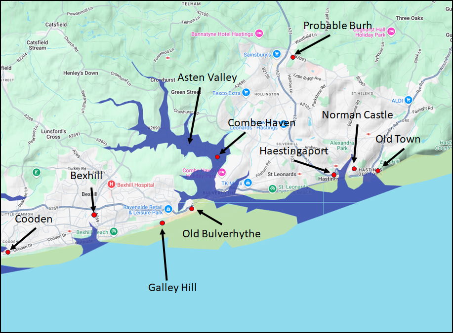 This map is my latest interpretation of the landscape near Hastings in 1066AD and is drawn using Google My maps.
The blue areas show the 4.5 metre coastline, probably the high tide mark at the time. The Green areas off the coast show eroded land since 1066AD which would probably be about 900 metres out into the English Channel.
The Asten river would have flowed along the coast to Hastings Haven where the modern castle would have over looked the river entrance, and the entrance to the port which was probably in the area of the modern Priory Road shopping centre.
So what is the evidence for this map, is there any ??
|
| |
|---|
Lidar map of East Sussex ▲ |
|---|
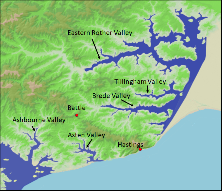
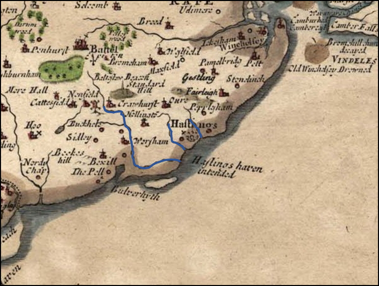
This map shows a Lidar image of East Sussex, which is colour coded for height above high tide level, as you can see the hills roughly go North West to South East with the rivers generally heading towards the South/South East.
The river valleys are shown in blue at a high tide level of about 4 metres to show effects of the high tide level without any sea defences.(see The Variable Ocean: Was the high tide level in Saxon times at Pevensey at about 4.5 metres ?)
I have omitted the Romney Marsh as this has changed significantly over time, please see our Landscape - The History of the Romney Marsh in maps.
The two main towns related to the Battle of Hastings are shown. As you all know the Battle of Hastings was not at Hastings but at the nearby town of Battle.
|
Lidar map of the area ▲ |
|---|
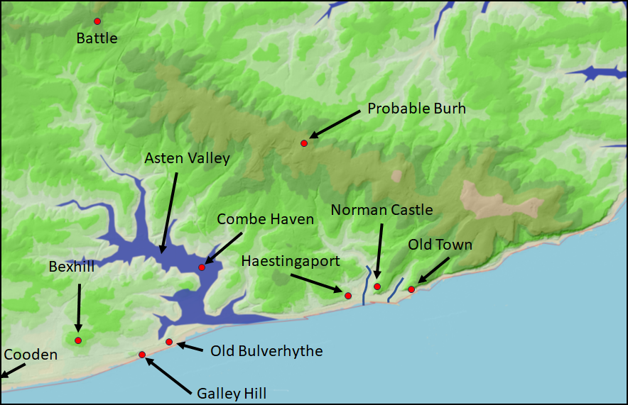 This is a close up Lidar map of the Hastings area showing the prominent ridge that goes from Battle to Fairlight. The blue boundary shows the 4.5 metre high tide mark of the Asten river and the blue lines showing the smaller streams around Hastings.
|
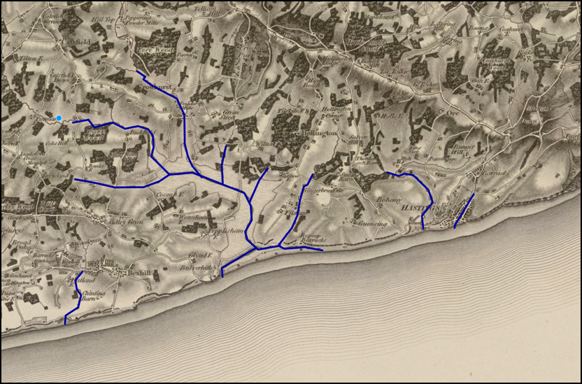
Ordnance Survey 1 inch Popular 1919-1930 ▲ |
|---|
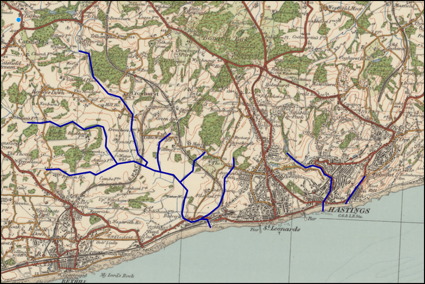 Lets start with a map from the early 1900's, this is an 'Ordnance Survey 1 inch Popular 1919-1930', this map can be seen by clicking the image above and derives from the 'National Library of Scotland'.
The blue lines show the path of the main streams in the area, and as you can see the Asten river arrives in the Channel between Bexhill and St leonards in the region of Harley Shute road.
|
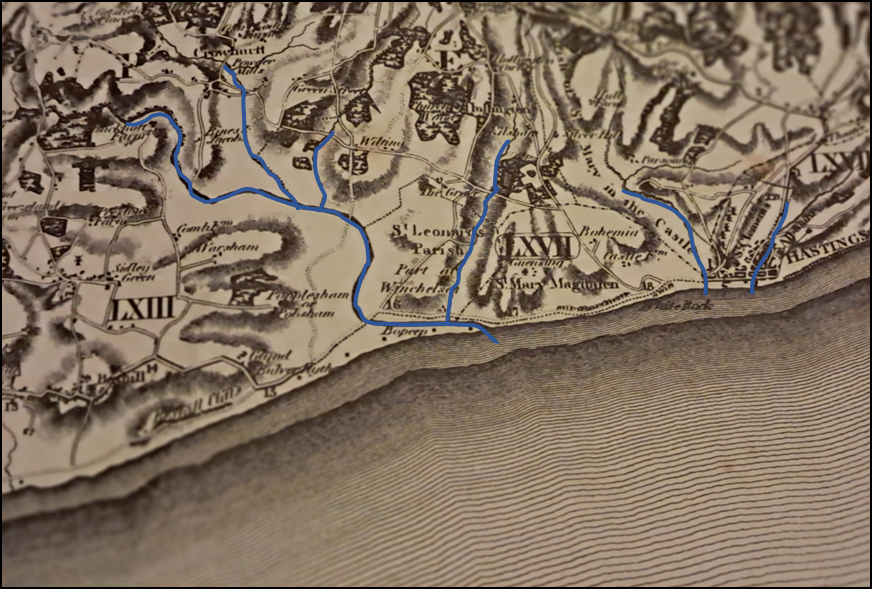
Ordnance Survey Old Series 1 inch published 1813 ▲ |
|---|
 This map now shows that the Asten river reaches the sea both Eastbound towards BoPeep Barracks and West towards Galley Hill.
|
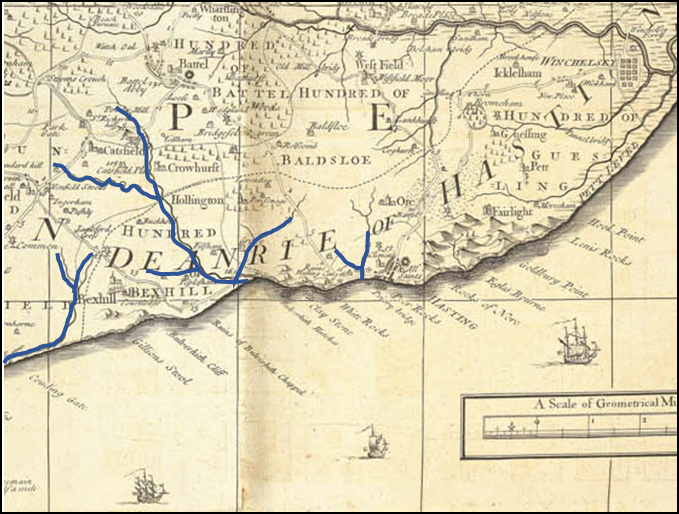
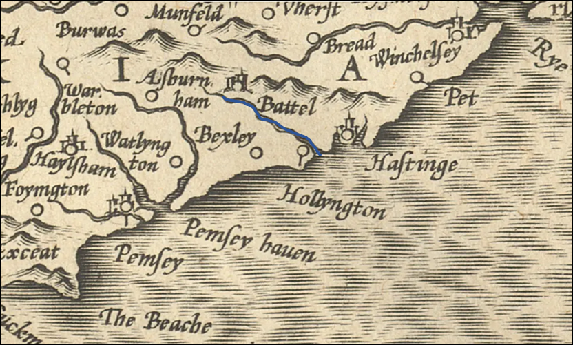
Yeakell and Gardners map published in 1787AD ▲ |
|---|
 This map now shows that the Asten river reaches the sea towards Hastings by running along the coast at modern St Leonards.
|
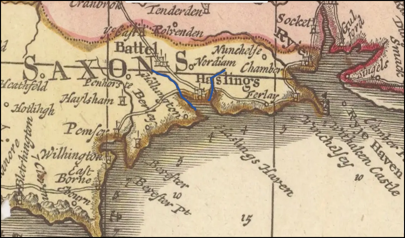
Budgen map published in 1724AD ▲ |
|---|
 The detailed accuracy is dropping as we go back in time, but the overall is what we are after. The Asten river is still heading towards Hastings for its outfall.
|
John Speed map published in 1610AD ▲ |
|---|
 John Speed's map is slightly more detailed but is just a copy of John Norden's earlier map.
|
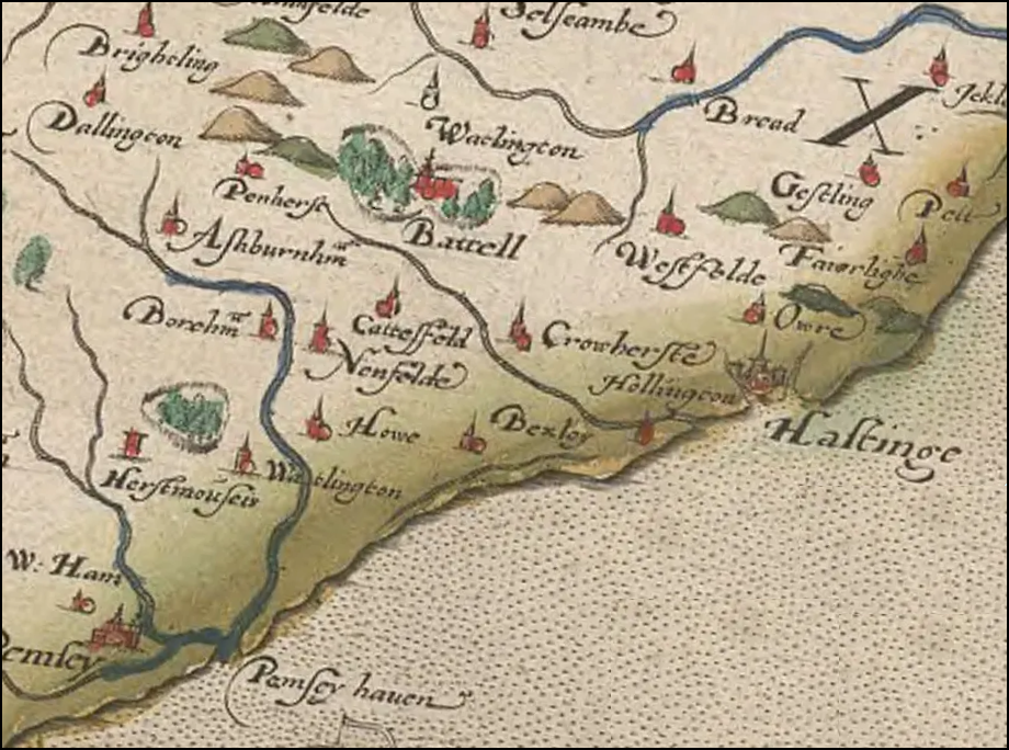
John Norden map published in 1594AD ▲ |
|---|
 As you can see the accuracy is degrading, but this shows the Asten heading further towards Hastings, but there is now an island off modern Bulverhythe, which implies a fair bit of erosion.
|
Mercator map published in 1595AD ▲ |
|---|
 We are now back to 1595AD and have lost the detail, but from this we can see that the area near the Norman Castle at Hastings stood further out into the channel, but was protected by land offshore of the White Rock and the Old Town.
|
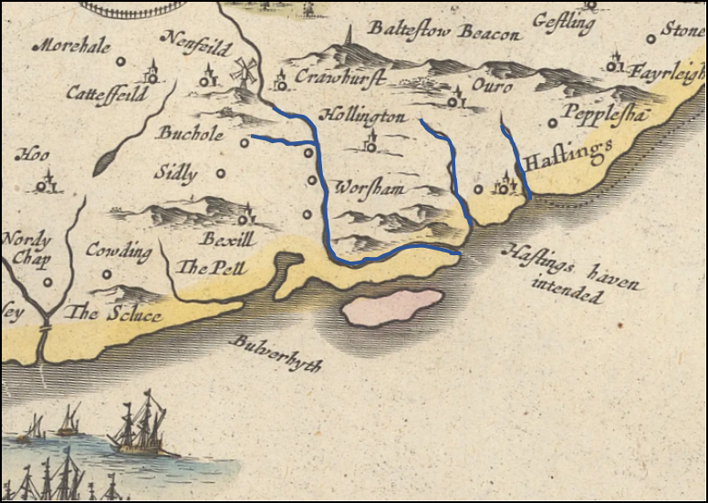
Matthäus Seutter map published in 1730AD ▲ |
|---|
 Although this is a later map, it is probably derived from a different original source than the rest of the maps above, and shows more close up details of Hastings in a protected bay.
|
Christopher Saxton map published in 1579AD ▲ |
|---|
 This is the earliest map that I could find, published by Christopher Saxton in 1579AD, he was a pupil of John Rudd(see below). This map appears to show a promontory of land off Bexhill and St Leonards, but the detail is not really good enough.
This map apparently was based on John Rudd's map of 1565AD when Rudd had been given permission by Elizabeth I to take a two year break to map the realm, this map has been lost, however it is believed that there is part of it - the Isle of Wight.
|
Conclusion ▲ |
|---|
|
This is the final rendering of the map of Hastings in about 1066AD
|
If you look at the Lidar map to the left you can see that the ridges seem to run to the South East, and the majority of the small streams running off these go either north east or south west. (clicking on the maps will show a larger map).
"This map also shows that Hastings was on a peninsula, with the Rother to the east and the Ashbourne to the west feeding into the Pevensey inlet, which in 1066AD was still an open tidal estuary extending well inland. These water boundaries meant that movement to and from Hastings by land was effectively limited to the ridge running north towards Battle and beyond — the narrowest point of which is near modern Netherfield."
Also from the more detailed Lidar map it would seem likely that there was a promontary into the sea near to modern Cooden (originally known as Cooling). To the east there is the area around Bexhill near to Pelham park where the Pell stream reached the sea. Further east there was another promontory that protruded from the Galley Hill area near to modern Bulverhythe and out into the Channel, which would most likely have streams that reached the sea towards the north east or south west.
If John Speed's map of 1610AD was correct then there was an island off Bulverhythe and St Leonards. This implies that the land was originally further out, and the island is also to the south east of Galley hill which would be logical if there was a promontary there. This map also shows the Aspen river running along the modern St Leonards sea front towards Hastings.
This map also implies what may have happened in the 1287AD storm (see Landscape - The 1287AD Storm and its effect on the Kent and Sussex Coast).
Here is the basis for the final map
If the land was originally a promontory, and there were streams running south west and north east, its possible that the 1287AD storm broke through a weakened area behind the 1610AD island and deposited vast amounts of shingle into the estuary of the Asten river blocking Combe Haven and across the Haestingaport harbour where the current Shopping Centre at Priory Meadow was.
This would have forced the Town to relocate to the position of the Old Town of Hastings where the net shops and fishing fleet currently are.
The 1610AD Island appears to have eroded away by the mid 1700's, so the promontory could have been even further out than my map shows.
|
| |
|---|
Further reading ▲ |
|---|
Awaiting article for common_further_reading
|
|
;)
)
)
)
)
)
)
)
)
)
)
#/media/File:Isle_of_Wight_by_John_Rudd_1570.jpg',800,1300))


