Senlac Hill was there only one? and what does it mean?
On this page I will try to put forward various comments on the origination of Senlac, and the possibility of where
it originates from.
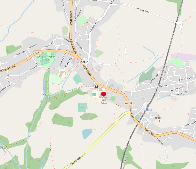
Senlac Hill is nowadays inside Battle Abbey in the small town of Battle in East Sussex and is shown by the red dot on the map below.
Firstly what evidence is there that Senlac Hill was relevent to the Battle of Hastings?
By looking at the documents available from the time of the Battle, there is only one reference to Senlac which comes from
Orderic Vitalis(Gesta Normannorum Ducum)
the relevent passage reads
' On the other side, the English troops, assembled from all parts of the neighbourhood, took post at a place which was anciently
called Senlac, many of them personally devoted to the cause of Harold, and all to that of their country, which they were resolved to
defend against the foreigners.'
The Battle Abbey Chronicles
make no mention of Senlac - that seems odd as its in the current Abbey Grounds, and if important would have had a mention in the text,
the Chronicles refer to Hegeland as the hill.
The name Senlac was introduced into English history by the Victorian historian E.A. Freeman who suggested that Senlac meant Sand Lake
in Old English with the Norman conquerors calling it (in French) Sanguelac('Blood lake').
OK so what does Senlac mean, there are a lot of possibilities some being decidedly unlikely.
If we look at the Anglo Saxon words, what are the possibilities for Senlac Hill:-
lac appears to derive from lacu a pond or lake.
sen There are a number of possibilities as to the derivation of sen which is not a saxon word as it stands, so most likely
has been shortened over time(a few hundred years from its early Saxon name), the monks who wrote the Chronicles of the time were mostly
Norman and wrote in latin so they may have been trying to write the sound of the locations.
The nearest words that could have been shortened are:-
sand meaning sand hence sandlacu
So this would mean sandy lake,
senn meaning to sin therefore sennlacu
So this would translate to sinners lake, but as the area was supposed to beunoccupied before 1066 I have discounted this word.
isen meaning iron so isenlacu
Translating to iron pond - interesting
aescen meaning ashen so aescenlacu
This would translate to the ash tree pond - again interesting
So Senlac would seem to be a descriptive term, and we are now left with Ash Tree Pond/Lake, Iron Pond/Lake or Sandy Pond/Lake,
so lets look at the landscape around Battle to see if we can find anything that might relate to the above translations, as
it is possible that there were a number of Senlacs in the area.
To the north of Senlac Hill there is a very steep valley with a spring that flows down into the Brede valley, the nearest pond
in that direction would have been towards Marley Lane a mile or so away but no reason to call it senlac as marley means marl island(marl
meaning clay).
To the south east are a few small ponds, but just the clayey ponds that cover the area. Please be aware that a lot of ponds that are
now in the area were caused by doodlebug explosions from World War 2 falling short of London or being turned over by typhoon fighters.
To the south there is now the pond created at Powdermills, but originally this may have been created by the Romans digging iron at
Pepperingeye a few hundred metres to the south east.
To the west towards Ashburnham we have an area known for its ash trees, and near to Ashburnham(Meaning the Stream in the Ash trees)
there are a number of lakes, probably formed again for iron working in Roman times, so there may be a second Senlac hill. Please
see the map below.
Finally to the North West of the abbey lies the hamlet of Beech(now Beech Farm) which was in the Domesday and was an iron working site.
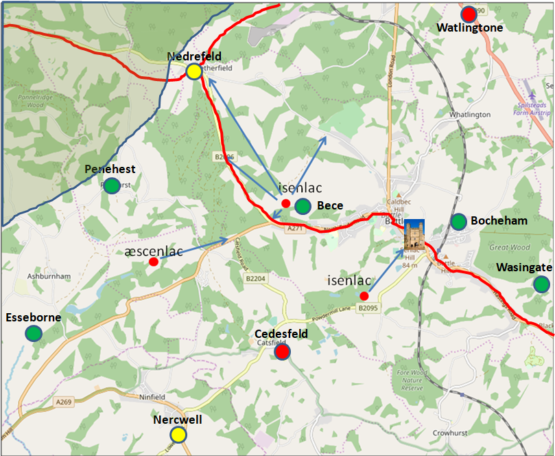
The above map shows possible other Senlac Hills based on the local geography, please take a look at the above details and make your own judgement on the location of Senlac.
Total Population(ex slaves) of the 27 Domesday Villages in 1086AD shown is 294
This would equate to a Fyrd(national service) of approximately 17 soldiers.
Please Note that the estimate for the Fyrd is based on 6% of the
population(excluding Priests and Slaves) being eligible for military duties.
| Summary of Domesday information for this map |
|---|
Population Overview |
|---|
| Villagers | 220 | |
|---|
| Cottagers | 58 | Thegns |
|---|
| Smallholders | 16 | |
|---|
Occupation Overview |
|---|
| Churches | 7 | |
|---|
| Mills | 1 | |
|---|
| Salthouses | 11 | |
|---|
| Ploughs | 172 | |
|---|
Land Overview |
|---|
| Plough Land | 136 | acres |
|---|
| Meadows | 69 | acres |
|---|
| Woodlands | 60 | acres |
|---|
Animals Overview |
|---|
| No Animal details recorded in Domesday |
Valuation |
|---|
| | AD1066 | AD1086 |
|---|
| Value(geld) | | 73 | 74 |
|---|
|