Anglo Saxon History Home Background Landscape Changing Landscape and Language Sea Levels in AD400(Pevensey) Sea Levels in AD400(The Wash) Sea level changes last 2000 years Andredsweald and Anderida Where are the Roman Roads History of the Romney Marsh The Great Storm 1287AD List of Landscape Documents Local The Haestingas The Cinque Ports 914AD Alfred the Great's fort in Hastings Battle Museum Battle History Society Villagenet Local Gazeteer World War 2 Tank database Simon the Piman(Raspberry Pi) Tourist Guides for the area Romans First Invasion 55BC Second Invasion 43AD Roman roads in Britannia Ptolemy Geographica Tribes MAP-Margary Roman Roads MAP-Roman Roads South East MAP-Roman Roads South West MAP-Roman Roads Wales MAP-Roman Roads South Midlands MAP-Roman Roads South Yorkshire MAP-Roman Locations Norfolk MAP-Roman Locations Essex MAP-Wealden Roads/Bloomeries Wealden Bloomeries 1st Century Wealden Bloomeries 2nd Century Wealden Bloomeries 3rd Century Wealden Bloomeries 4th Century MAP-Antonine Itinery I Roman Industry in the Brede Valley Decline in Roman Wealden Ironworking The Gallic Empire 260AD - 274AD Types of Roman Fortification List of Roman Documents Saxon Chronicles 449AD Hengest & Horsa arrive 455AD Hengest & Horsa defeat Wurtgern 457AD Hengest & Horsa take over Kent 460AD Hæstinga Saxons arrive 477AD Cymensora 485AD Suth Saxons Mercredesburnan 491AD Suth Saxons Pevensey 914AD Burghal Hideage Locations - 449AD Ebbsfleet Locations - 455AD Agelesþrep Locations - 485AD Mearcredesburnan Stede Locations - 914AD Eorpeburnan List of Saxon Chronicles Documents 1066 Battle Documentary Evidence Available Documents 1 Anglo Saxon Chronicles 2 Battle Abbey Chronicles 3 Bayeux Tapestry 4 Carmen Guy d'Amiens 5 Florence of Worcester 6 Henry of Huntingdon 7 Master Wace 8 Orderic Vitalis(Gesta) 9 William of Jumièges(Gesta) 10 William of Malmesbury 11 Quedam Exceptiones Reference to Locations Phases of the Events Phases 1066AD 1 Background 1066AD 2 In Normandy 1066AD 3 Channel Crossing 1066AD 4 The Landing 1066AD 5 Feast after Landing 1066AD 6 Building the Forts 1066AD 7 Raiding the Area 1066AD 8 Warning to Harold 1066AD 9 Stamford Bridge 1066AD 10 Harold returns to London 1066AD 11 William is Alerted 1066AD 12 Exchange of Messages 1066AD 13 Defenses 1066AD 14 Harold Reconnoitres 1066AD 15 Preparations 1066AD 16 The Night Before 1066AD 17 The Battle 1066AD 18 Harold is Killed 1066AD 19 The English Rout 1066AD 20 After the Battle 1066AD 21 The Malfosse Warriors, Weapons & Snippets Saxon - Huscarl Saxon - Fyrd(Fyrð) Senlac Hill The Malfosse The Hoar Apple Tree The Shield Wall Salt Production near Hastings The Battle of Jengland 851AD William's Ship List Norman/Viking Ships and stuff Norman bows and crossbows Harold was NOT killed by an arrow The Time Team view of the Battle 1066AD Landscape Details 1066AD Sailing from Normandy 1066AD Norman Landing 1066AD Possible Fort 1066AD to Pevensey and Hastings 1066AD Manors Wasted 1066AD Manors All 1066AD Warning to Harold 1066AD Harold to Hastings List of 1066AD Documents List of 1066AD Weapons 1086AD Domesday Boundary of Anderida Domesday Hursts Post Domesday Hursts Domesday Manors Wasted UK Norfolk Salt Production Salt Production near Hastings The Wash at 1086 The Humber estuary at 1086 Domesday County details B Bedfordshire Domesday Population Berkshire Domesday Population Buckinghamshire Domesday Population Domesday County details C Cambridgeshire Domesday Population Cheshire Domesday Population Cornwall Domesday Population Domesday County details D Derbyshire Domesday Population Devon Domesday Population Dorset Domesday Population Domesday County details E Essex Domesday Population Domesday County details G Gloucestershire Domesday Population Domesday County details H Hampshire Domesday Population Herefordshire Domesday Population Hertfordshire Domesday Population Huntingdonshire Domesday Population Domesday County details K Kent Domesday Population Domesday County details L Leicestershire Domesday Population Lincolnshire Domesday Population Domesday County details M Middlesex Domesday Population Domesday County details N Norfolk Domesday Population Northamptonshire Domesday Population Nottinghamshire Domesday Population Domesday County details O Oxfordshire Domesday Population Domesday County details R Rutland Domesday Population Domesday County details S Shropshire Domesday Population Somerset Domesday Population Staffordshire Domesday Population Suffolk Domesday Population Surrey Domesday Population Sussex Domesday Population Domesday County details W Warwickshire Domesday Population Wiltshire Domesday Population Worcestershire Domesday Population Domesday County details Y Yorkshire Domesday Population Place names Translate my Location Celtic name snippets Jutish name snippets Roman name snippets Saxon name snippets Viking name snippets Norman name snippets Modern name snippets Villages containing EY/EYE/SEA Villages containing HAM Villages containing TON Villages containing CASTLE Sussex Locations with ING Domesday Sussex with ING Kent Locations with ING Sussex Locations with HURST Loads of Village Translations Res Battle of Hastings 1066AD ‑ Norman Cavalry at the Battle of Hastings Norman Cavalry and likely tactics Norman Cavalry and likely tactics Historic details of these knights Viking Settlement in Normandy 911AD Viking Horsemen Norman Cavalry The wooded areas around Battle Conclusion Historic details of these knights ▲ 
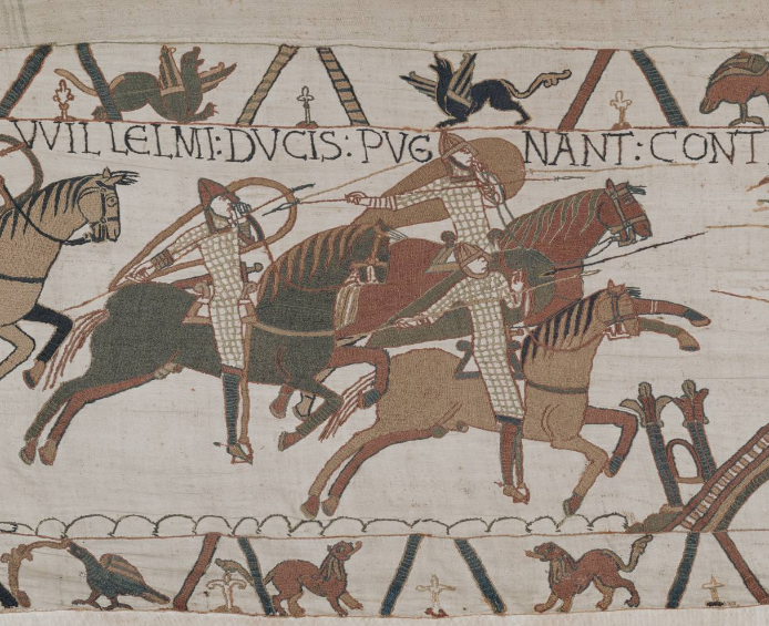
The Bayeux Tapestry gives us the best view of Knights of the period, with the majority of images showing the cavalry throwing spears overhead. Viking Settlement in Normandy 911AD ▲ From Wikipedia: The siege of Chartres took place in spring 911AD during the age of Viking incursions in Europe. The Viking leader, Rollo, and his men laid siege to the city of Chartres, in West Francia. But they failed to achieve their goal before the arrival, in July 911AD, of a relief army sent to battle them. The engagement that ensued resulted in the defeat of the Norsemen. Following Rollo's defeat, the King of the West Franks, Charles the Simple, granted him a territory in the northern lands of his kingdom in exchange of an oath of fealty and his religious conversion. This territory, located between the mouth of the Seine and Rouen, a city Rollo had previously raided and seized in 876, officially formed the fief known as the County of Rouen. This county, through kinship in the decades to come, would expand into what came to be known as the Duchy of Normandy. Prior to the settlement of the Vikings, Brittany had been made into a Dukedom after they defeated Charles the Bald at the Battle of Jengland in 851AD Battle of Jengland AD851 - implies a quick defeat for Harold at Hastings 1066AD If you take a look at the tactics the Bretons used in the above article and the images from the Bayeux it would seem likely that the Normans copied the Breton tactics of riding up to the enemy, throwing spears and then retiring to reload. This was of course more likely after Brittany was defeated by the Normans in 1065AD at the Battle of Dinan, and became affiliated with Duke William. Viking Horsemen ▲ There appears to be no evidence for Vikings to fight from horseback and they just appear to have been used as fast transport for the more elite troops, providing fast deployment. This was recorded when the Viking Great Army invaded Britain in 865AD, and also prior to this in A.D. 893 when the Anglo Saxon chronical records 'This year went the large army, that we before spoke about, back from the eastern district westward to Bologne; and there were shipped; so that they transported themselves over at one time with their horses withal.' The Saxons appeared to use the same tactics, especially with the Huscarls and their Viking axes where fighting on horseback with a large axe is impractical because the weight of the weapon would make the horsemen unbalanced when swinging it. Norman Cavalry ▲ From the Bayeux and some of the Chronicles it would seem that the Normans raced up to the enemy, threw spears then charged in with their swords, or waited until the Saxons followed up a retreat and then cut the stragglers down. We should also realise that the Norman Knights rode smaller horses than the later steel plate protected Norman Knights, as their ring mail armour was lighter and hence the horses had not been bred to carry heavily armoured knights that would charge the enemy with long lances. So we have to think of them as lightish protected cavalry with range weapons. The wooded areas around Battle ▲ 
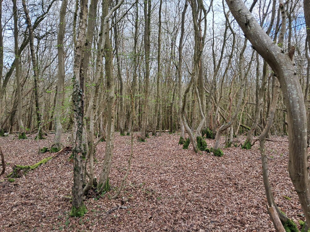
The great Oak Forest of Andredsweald surrounded the Hastings Peninsular and had only been cut down to for construction, shipbuilding and iron working for about 10 miles from Hastings. See The Great Forest of Andredsweald - Anglo Saxon Chronicles The image to the left shows the current woodland around the Battle area, and shows how dense the trees are, this would make it very difficult to take horses through the forest. The Forest was looked on as being impassible except where the old Ridgeway's or Roman roads passed through, unless you lived in the Forest. This would have made it very difficult to leave the area by road, and by the same token, the local forest would provide excellent timber to build ships, to sail away from the area. Conclusion ▲ The Norman Cavalry was in general a much lighter fast moving force that preferred to fight by throwing spears and then charging in with their swords when the opportunity arose. Cavalry being deployed in the Hastings area was not really the best idea, as the area was wooded, with a forest nearby, and very limited land routes to allow the force to leave the area. The much more open land of Kent would make a cavalry force much more effective, so why did he land in this area? Battle of Hastings 1066AD - Why the Hastings Area was important to Duke William Copyright saxonhistory.co.uk 2013 - 2025Contact SimonAuthor Simon M - Last updated - 2025-02-11 11:00:57All pages on our site (Sitemap)