Battel
The town of Battle first named by the Normans at the start of the building of St Martins Abbey in 1070AD which took till 1094AD to complete. The town of Battle grew up around the abbey to provide for the monks.
Beche
Modern Beech estate - this area is to the West of Battle near to the junction of the A271 and the B2096, generally to the north of the A271.
Bodeherste or Bodehurst
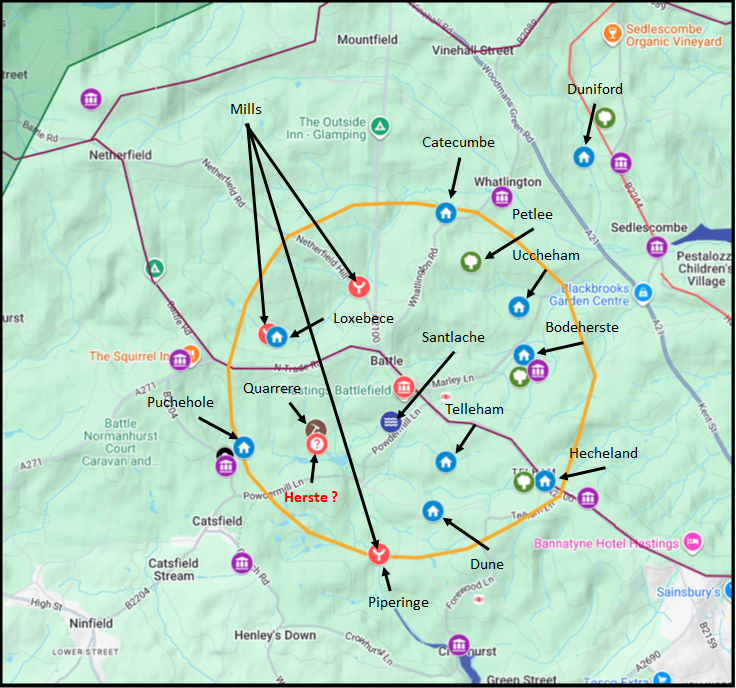
This area is now known as Bathurst, the original Saxon name is derived from bode and hurst derived from hyrst - A clearing in the Forest, most were settled after Domesday.
Bodeherstegate
This area is now known as Bathurst, the original Saxon name is derived from bode and hurst derived from hyrst - A clearing in the Forest, most were settled after Domesday, Bathehurstgate probably is the leuga boundary gate int the wood.
Bretherste
No modern place has been identified for this name. The element
hyrst indicates a clearing in the forest, and breðer or
broðor could suggest a monastic or fraternal association, possibly
a hermitage or small religious house predating the Abbey. Location unknown.
Catecumbe
Visible on old maps as Carcombe Wood, located just north of the Whatlington
road near the modern Whatlington/Leeford area. The name derives from
cate cumb — the valley of the wild cat.
This area can be seen on old maps as Carcombe wood National Library of Scotland, amd this can be found just north of the Whatlington road near the modern Whatlington/Leeford area.
Celvetege
No modern place has been identified. The name may derive from
cealf tæge — the calf enclosure — suggesting it was pasture land
south of the Abbey church. Location unknown.
Chapenore
No modern place has been identified. The element ora means a shore
or bank, and ceap means a market or trading place, suggesting this
may have been a trading point on a stream bank within the leuga. Location
unknown.
Claverham
This is possibly the west side of the town where the current Claverham School is located. The name derives from clæfre hamm — the valley settlement where clover grows, but this is a settlement named after the Domesday book and when ham was being changed from its original meaning to modern hamlet. One of the two Gildhalls in the town was located here.
Dune
Duniford
One of the three woods named within the leuga alongside Hecheland, Bodeherste
and Petlee. No modern place has been identified. The name derives from
dun ford — the fort near the ford — suggesting a stream crossing on
the hillside within the leuga.
Dunintune
No modern place has been identified. The name derives from dun tun
— the hill settlement — a common Saxon place name element. Its position in
the Chronicles text places it within the leuga to the north.
Hecheland
This is most likely to be at modern Telham
Hechilande
This is most likely to be at modern Telham
Herste
This is most likely to be near Quarrie
La Stene
No modern place has been identified. The element stæne or
stén means stony ground or a stone, possibly indicating a boundary
marker or a notable stone feature within the leuga.
Loxbece
No modern place has been identified by this name. One of the Abbey's mills
was located here — described as lying under Loxbece — suggesting a valley
stream location within the leuga. The name may derive from
locc bece — the enclosed stream.
Petlee
One of the three woods named within the leuga. The Chronicles record it as
containing one wist of 48 acres in domain. No modern place has been
identified, though its position in the boundary description places it to the
north of the Abbey between Hecheland and Uccheham.
Peperinge
The Chronicles record one of the Abbey's mills here, described as partly
within and partly without the leuga to the south of the Abbey. The name
derives from papor ing — derived from the protected village where paper – papyrus(reed like) plants grow . This is on the south eastern edge of the leuga at Peppering near Crowhurst.
Plesseiz
A Norman French name rather than Saxon, deriving from plesseis —
an enclosure made of interlaced branches. Its appearance here suggests it
was named or renamed after the Conquest, possibly a garden enclosure within
the Abbey grounds.
Puchehole
No modern place has been identified. The name may derive from
púca hol — the pucca's hole — a
common type of Saxon place name for an unusual landscape feature such as a
bubbling spring. Its position in the leuga boundary description places it to the south west.
Quarrere
The Chronicles describe this as a piece of land of four acres lying between
the orchard adjoining the Abbey and the park on the south side. The name
derives from the Norman French quarrière — a quarry — suggesting
stone was extracted here, possibly for the Abbey's construction.
Richelherste
No modern place has been identified. The element hyrst indicates a
forest clearing, and ricel may derive from a personal name or from
rice meaning powerful or wealthy, suggesting an established
settlement within the forest. Five wists are recorded here.
Santlache
Santlache appears in the Abbey Chronicles as ordinary agricultural land
within the leuga, with 31 acres recorded near the infirmary. The name is the
Saxon precursor of the later Norman French Senlac, and has
conventionally been identified as the battlefield. However the monks, writing
within living memory of the battle, make no special mention of it — they
record it simply as farmland with no indication that it was the site of the
most significant military event in English history. This is difficult to
explain if Santlache and the battlefield were the same place. For a full
discussion see Senlac
Hill — where is it and what does it mean?
St Mary
The church of St Mary is mentioned several times in the Chronicles in
relation to surrounding land. One of the three Abbey orchards lay to the
north of the church, where the monks' garden was also located. The church
predates the Abbey and is likely to have been the existing Saxon church
serving the local settlement before the Conquest.
Strellewelle
No modern place has been identified. The name derives from
stræl wielle — the arrow spring or the straight stream spring —
possibly describing a fast-flowing spring or a straight channel of water
within the leuga. Four acres are recorded here held by Gilbert the stranger.
Telleham
Telleham is most likely to have been between Telham Hill and Telham Manor in the valley as Telham is derived from tilia meaning a cultvator of land and ham meaning a valley settlement.
Uccheham
This are can be found on the valley floor between Whatlington and Marley Lane, the name is derived from
uck derived from aac - oak trees and ham derived from hamm - Denotes a piece of land surrounded with paling, wicker-work, etc., and so defended against water, which would otherwise wash it away, so a valley settlement or settlement with a jetty.
Wetlingetune
| ;)
)
)