| Battle of Hastings 1066AD
Location - 2 Hecheland where is it and what does it mean ? |
|---|
| | |
|---|
Documentary References |
|---|
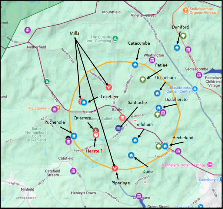
If you take the references from the Battle Abbey Chronicles regarding the leuga(league) the area owned by the Abbey.
From without Bodeherste on the east is the boundary of the Leuga near the land of Robert Bos and Boundary of it runs near the land of Roger Moin as far as Hecilande and includes Hecilande near the land of William Fitz Robert Fitz Wido and the land of Croherste on the south.
On the sabbath they shall go with their own horse whithersoever they are ordered Between Hecheland and Bodeherste is one wist with the like labour and pence In Telleham are held seven wists which shall do all the labour in the manner above described
In Uccheham are three wists with the meadow called Hanwisse Bodeherstegate as far as the road near Hechilande lies a very large uncultivated plain In Hechilande are two wists In Santlache reaching as far as the infirmary are held 31 acres this place is called Dune.
Besides these the leuga includes three woods namely Hecheland Bodeherste and Petlee and a fourth which is called Duniford.
| Can we work out its location |
|---|
From the above documentation it would appear that Hecilande, Hecheland or Hechilande is between Bathurst and Crowhurst and between Bathhurstgate and Santlache and also Bathurst and Telham.
So the leuga description goes clockwise from Bathurst to Hechiland to Telham and or Santlache.
Modern Bathurst is a wooded area currently known as 'Battle Great Wood' and modern Telham is on the Hastings road.
Santlache is a small lake to the south east of the Abbey.
However the snippet ham in Telham implies that this was a valley settlement, so it was most likely to be in the valley behind modern Telham court, near to Telham farm, but over time as the road develops then the name migrates from the valley to the ridge.
Hechiland is described as 'it runs near the land of Roger Moin as far as Hecilande and includes Hecilande'
This implies that Hecilande was a settlement on the Hastings road near the boundary of the leuga. This is most likely to be where modern Telham is located.
| Map of Battle Abbey Lands |
|---|
This map is taken from our analysis of the lands of Battle Abbey, please click on the map for a larger image.
Battle of Hastings 1066AD Location - 1 the Lands of Battle Abbey from the Abbey Chronicles
| | |
|---|
Possible meanings of Hecheland |
|---|
So the prefix snippet is either Heci, Heche or Hechi and land which means the same as the modern meaning.
If we look at Anglo Saxon words, there is no Heci, Heche or Hechi but there are a few other possibilities:
hecge - an enclosure, a fence, hedge
hecg - an enclosure, a fence, hedge
hege - an enclosure, a fence, hedge
hécen - a small goat
heáge - high
It is worth considering what Hecheland actually describes in a broader landscape context. If the name derives from heáge land — simply "the high land" — then it originally described elevated ground lying between the battlefield and Hastings. If the battle took place further inland, around Netherfield for example, then the high ground between that location and Hastings would lie considerably further back from the coast than is currently assumed.
Once William founded the Abbey at Battle, however, the monks were obliged to define their leuga — the league of land surrounding the Abbey — and in doing so they needed a Hecheland. With the Abbey now established at Battle, the "highland towards Hastings" closest to them would naturally have been the elevated ground along the Hastings road near Telham, and that is the location that became recorded in the Chronicles as Hecheland. The name may therefore have been applied to a new location, simply because it best fitted the description from the Abbey's new vantage point.
| Conclusion |
|---|
|
The translation most commonly used by scholars is that Hecheland means hedge land. My own view is that it derives from heáge land, meaning "the high land," and that this was originally a descriptive term for elevated ground lying between the battlefield and Hastings rather than a fixed settlement name.
If the battlefield was at Battle, then the high ground between the Abbey and Hastings is near Telham, and that is where the Chronicles place Hecheland. But if the true battlefield lay further inland — towards Netherfield — then the original Hecheland would have been a quite different piece of ground. The monks, having built the Abbey at Battle on the orders of William, had no choice but to find their own Hecheland within their leuga, and the elevated ground near Telham fitted the bill. This means we cannot safely use the Chronicles' reference to Hecheland as independent evidence for the battlefield location — it may simply reflect where the monks drew their boundaries, not where the fighting actually took place.
|
|
|
;)
)


