| Battle of Hastings 1066AD - Y - A Bridge Collapses after the Battle |
|---|
|
| | |
|---|
Introduction ▲ |
|---|
Master Wace records one of the lesser-known details of the Battle of Hastings aftermath: as the surviving Saxon army fled, so many men crowded onto a bridge that it collapsed under the weight, and many fell into the deep river below. The obvious assumption is that this was London Bridge — but the numbers simply don't support it.
London Bridge is 63 miles from the battlefield. At any realistic running speed, even with Norman cavalry in pursuit, fleeing soldiers would take between 26 and 36 hours to cover that distance. By the time any significant number reached the Thames the pursuit would have long since ended and the crowd would have thinned out naturally. A distribution analysis of 6,000 men on the roads shows the flow arriving at London Bridge never exceeds around ten people per minute — nowhere near enough to collapse a bridge.
This page works through the escape routes available from the battlefield, considers what percentage of terrified and largely untrained levy troops would realistically head into the Andredsweald rather than follow the road, and identifies a far more plausible candidate for the collapsed bridge — just seven miles from the battlefield at Bodiam, where the tidal Rother would have been deep, the Saxons would have been funnelling into a narrow crossing, and the Normans would genuinely still have been close behind.
| | |
|---|
Documentary Reference ▲ |
|---|
There is only one reference to this event, so it is not corroborated hence shown in red:
Master Wace and the 'Roman De Rou'
The following translation comes from 'The Edgar Taylor translation of the Roman De Rou' and appears after Harold is killed and the battle lost.
The English who escaped from the field did not stop till they reached London, for they were in great fear, and cried out that the Normans followed close after them. The press was great to cross the bridge, and the river beneath it was deep; so that the bridge broke under the throng, and many fell into the water.'
This account appears only in Master Wace's Roman de Rou, written roughly
a century after the battle. None of the other chronicles — not the Anglo Saxon
Chronicles, not Orderic Vitalis, not William of Jumièges — mention a bridge collapse
during the retreat. It is therefore treated here as a single uncorroborated source,
which does not make it false but does mean it cannot be taken as established fact.
| | |
|---|
This implies London Bridge but could it have been before ? ▲ |
|---|
|
The natural assumption is that the bridge in question was London Bridge, since the
fleeing Saxons are described as heading for London. But London is approximately 63
miles from Battle by road — probably further in 1066 — which means even a fast
retreat on foot would take between 26 and 36 hours. Over that distance and that time,
a crowd of several thousand men spreads out considerably. The distribution chart below
shows that even at peak arrival the flow across the bridge would never have exceeded
around ten people per minute — nowhere near enough to collapse a bridge. Add to this
that soldiers from Kent, Surrey, Sussex and Hampshire would have had no reason to
cross the Thames at all, and the London Bridge identification becomes very difficult
to sustain.
| | |
|---|
Chart showing the distribution of Saxons reaching London ▲ |
|---|
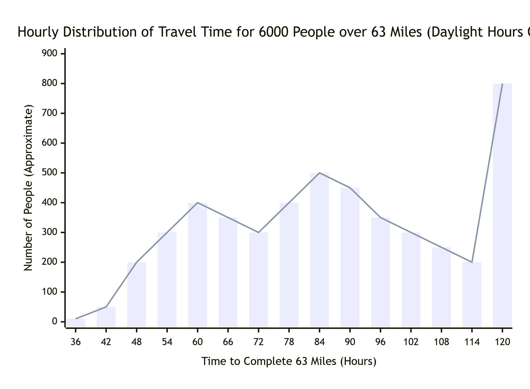
This chart shows the distribution of people reaching London Bridge over time.
Even at peak, the flow never exceeds around ten people per minute.
| | |
|---|
What Escape routes are there for Saxons fleeing ▲ |
|---|
So lets now try to work out the escape routes to see if there is another bridging point that could fit this description.
The map below shows the landscape in 1066AD, and as you can see, the Forest of Andredsweald surrounds the Hastings area. This is based on the Domesday records please see Anglo Saxon Chronicles - 892AD - The Great Oak Forest of Andredsweald for further details.
| 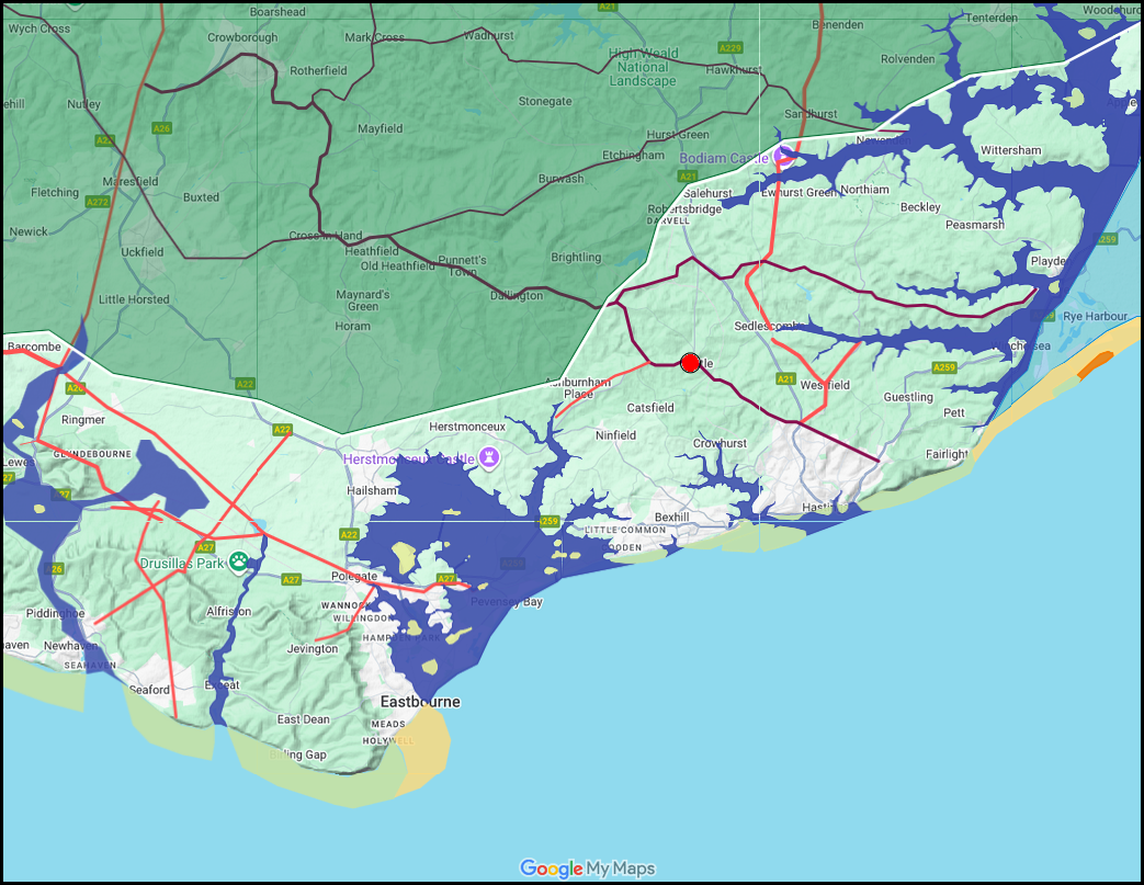
The red dot show the traditional location for the Battle at Battle Abbey.
| What numbers of escaping troops would go into a Forest ▲ |
|---|
The Forest of Andredsweald surrounded the Hastings area on three sides, which
raises the question of how many fleeing soldiers would have taken to the trees rather
than the roads. For an army consisting largely of levies unfamiliar with the local
landscape the answer is: very few. A terrified conscript in unknown territory follows
the crowd, and the crowd follows the road. The forest offers no visible path, no
known destination, and no guarantee of food, water or shelter. Even setting aside the
genuine medieval fear of deep woodland, the practical calculation for an exhausted
levy is straightforward — the road is dangerous but it leads somewhere. Somewhere
between 5% and 15% of the fleeing force might have broken for the trees, most likely
the wounded who could not keep pace, those trapped at the very rear with no other
option, and the rare individual with enough local knowledge to use the forest
deliberately. The great majority — 85% or more — would have stampeded down the
nearest road.
| | |
|---|
Roads versus Forest - the roads win ▲ |
|---|
|
Beyond the practical obstacles, the forest presented a psychological barrier that
should not be underestimated. For a medieval levy, deep woodland was not simply
difficult terrain — it was the edge of the known world. The Forest of Andredsweald
was one of the largest and oldest in England, ancient enough to have accumulated
centuries of folklore about what lived within it. A terrified conscript from open
farmland, already in a state of panic, would associate the treeline with bandits,
wolves, and forces considerably more frightening than Norman cavalry. The road,
however dangerous, was part of the human world. The forest was not. For the vast
majority of fleeing levies, turning into the trees was not a rational option they
considered and rejected — it simply would not have occurred to them as a choice
at all.
| 
The red dot show the traditional location for the Battle at Battle Abbey, the yellow line the likely escape routes.
| The most likely escape route ▲ |
|---|
|
If the battle was fought at the Abbey site with William attacking from the Hastings
ridge, the Saxon escape routes were constrained by the forest. The most likely line
of retreat runs north along the A271 to Netherfield, where the road splits. One
branch enters the forest toward Crowborough, eventually reaching the River Eden at
Edenbridge — about 30 miles from Battle on modern roads — before continuing north to
London. The other branch follows the Mountfield ridgeway to Cripps Corner, joining
the old Roman road from Westfield to Rochester, then descends to Bodiam where the
Romans had built a bridge across to the causeway over the Rother. In 1066 the Rother
was still a tidal sea inlet — wide, deep, and unbridgeable except at this point.
| | |
|---|
Conclusion ▲ |
|---|
|
The two candidates are therefore Edenbridge on the River Eden and Bodiam on the
Rother. Edenbridge is around 30 miles from the battlefield; Bodiam is around 7.
Master Wace specifically says the Normans were close behind the fleeing Saxons,
which strongly favours the nearer crossing. At 7 miles from the battlefield, and
with the forest closing in on either side of the road from Cripps Corner, the
retreating Saxons would have been funnelling into an increasingly narrow corridor
with Bodiam as the only viable river crossing. The distribution chart shows that at
roughly 50 minutes after the battle's end a significant concentration of men would
have been arriving at the bridge simultaneously — enough to overload a timber
structure over a deep tidal river.
The most likely identification for Master Wace's bridge is therefore the crossing
at Bodiam, not London Bridge. This is consistent with the single source we have,
with the landscape constraints, and with the military logic of a pursuit that was
still close enough to the battlefield to be pressing hard on the Saxon rear. It also
adds a further piece of circumstantial evidence that the battle, if fought at the
Abbey site, produced a retreat northward through the Rother valley rather than
directly toward London.
| 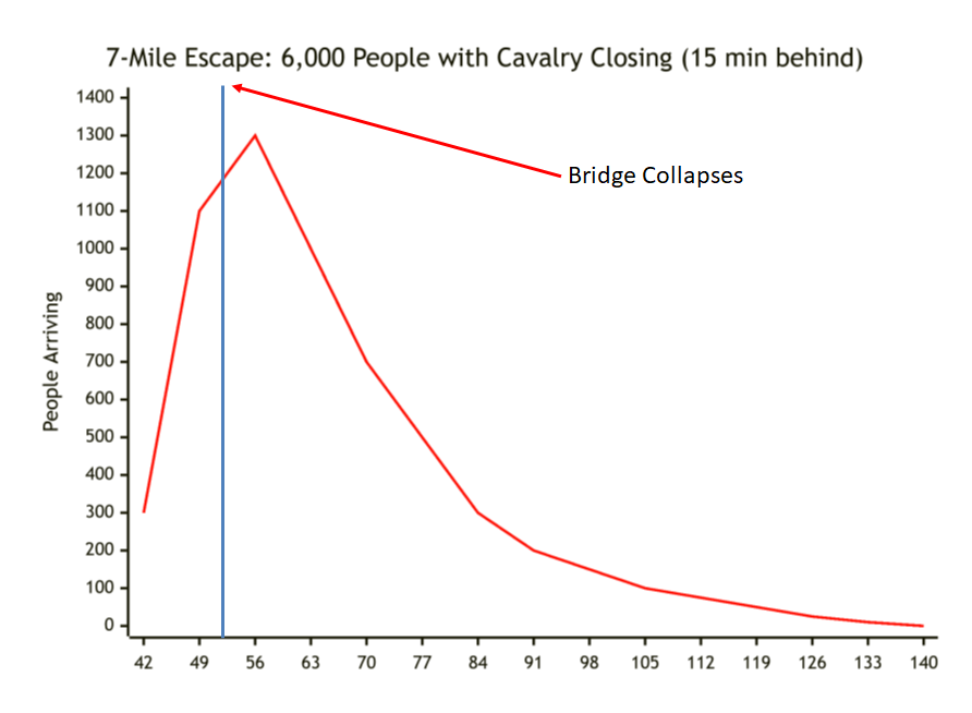
This chart is calculated for a starting force of around 6000 men, of whom only
about 1200 would have escaped via this route. Given that the Saxons had probably
lost around 1500 men before the shield wall broke, the actual fleeing force was
closer to 4500, meaning perhaps 1000 men reaching Bodiam.
|
|
|
|
;)
)
)
)
)


