| Battle of Hastings 1066AD
Location - Site 1 - The Hoar Apple Tree |
|---|
|
| Who suggested this site and where is it ? ▲ |
|---|
A site proposed by Rebecca Welshman and Simon Coleman on their website, the Battle of Hastings at Heathfield.
We analyse the relevance of the haran apuldran (‘Hoar Apple Tree’) in the ‘D’ text of the Anglo-Saxon Chronicle as an original name for the battlefield and discuss the survival of this name in medieval deeds concerning a nearby place ‘Horeapeltre’. We consider the military and cultural reasons why the battle might have taken place near here and show that the haran apuldran was probably a military assembly point.
Please take a look at the above website, there seems to be some valuable research carried out for this website.
| Site Concept ? ▲ |
|---|
The argument is that the Saxons forces mustered at Horeapeltre which is where North Down in Heathfield is currently located, this is approximately at the junction of Newick Lane with the A265.
And then the battle took place just outside Cade Street in an area to the North east of Punnets town known as Slaughter Common, this is about 1.5 miles (2.5Km) from the mustering point at Horeapeltre.
| Slaughter Common ▲ |
|---|
The name Slaughter Common seems to have been recorded in:
The Highways and Byways of Sussex - V.E.Lewis 1904
Slaughter Common, near Heathfield, is said to be the scene of a more wholesale carnage, Heathfield people claiming that there Caedwalla in 635 fought the Saxons and killed Eadwine, king of Northumbria. Sylvan Harmer, in his manuscript history of Heathfield, is determined that Heathfield shall have the credit of the fray, but, as a matter of fact, if Slaughter Common really took its name from a battle it was a very different one, for Caedwalla and Eadwine met, not at Heathfield, but Hatfield Chase, near Doncaster.
From a historic point of view, the only recorded Battle that could even possibly have been here from the 6 or 700's was the battle between King Offa and the Haestingas in 771AD, where the Haestingas were defeated and absorbed into Mercia.
This battle site has never been found, but would have needed to be on the border of the Kingdom of the Haestingas, so this is a possible site but not for Caedwalla and Eadwine but this would seem the only possible reason for this legend.
| Landscape details effecting the site ▲ |
|---|
William of Jumièges
However confidence returned to the fugitives when they found a good chance to renew the battle, thanks to a broken rampart and labyrinth of ditches.
Orderic Vitalis
(The Normans, finding the English completely routed, pursued them vigorously all Sunday night, but not without suffering a great loss ; for, galloping onward in hot pursuit, they fell unawares, horses and armour, into an ancient trench, overgrown and concealed by rank grass, and men in their armour and horses rolling over each other, were crushed and smothered.
Master Wace
and they had moreover made a fosse, which went across the field,
There he said he would defend himself against whoever should seek him ; and he had the place well examined, and surrounded it by a good fosse, leaving an entrance on each of three sides, which were ordered to be all well guarded.
And now might be heard the loud clang and cry of battle, and the clashing of lances. The English stood firm in their barricades, and shivered the lances, beating them into pieces with their bills and maces. The Normans drew their swords and hewed down the barricades, and the English in great trouble fell back upon their standard, where were collected the maimed and wounded.
Henry of Huntingdon
But Harold had formed his whole army in close column, making a rampart that the Normans could not penetrate. Duke William therefore commanded his troops to make a feigned retreat. In their flight they they happened unawares of a deep trench which was treacherously covered into which numbers fell and perished. While the English were engaged in pursuit, the main body of the Normans broke the centre of the enemy's line, which being perceived by those in pursuit over the concealed trench, when they were consequently recalled most of them fell there.
Florence of Worcester
before a third of his army was in fighting order. He gave them battle at a place nine miles from Hastings, where they had built a fort. The English being crowded in a confined position.
The Chronicles of Battle Abbey
here lay between the hostile armies a certain dreadful precipice, caused either by a natural chasm of the earth, or by some convulsion of the elements. It was of considerable extent, and being overgrown with bushes or brambles was not very easily seen, and great numbers of men — principally Normans in pursuit of the English — were suffocated in it
The Bayeux Tapestry
has a scene where horses are seen vertically and a very rough piece of ground goes up to the Saxon positions, this could also be interpreted as a ditch in front of the Saxon lines with men and horses falling into it. A further interesting part of this image is that the legs of the Saxons at the top of the hill are behind the hilltop which could be interpreted as defensive shieldwall above the fosse. (see below)
| Overall map of the Area ▲ |
|---|
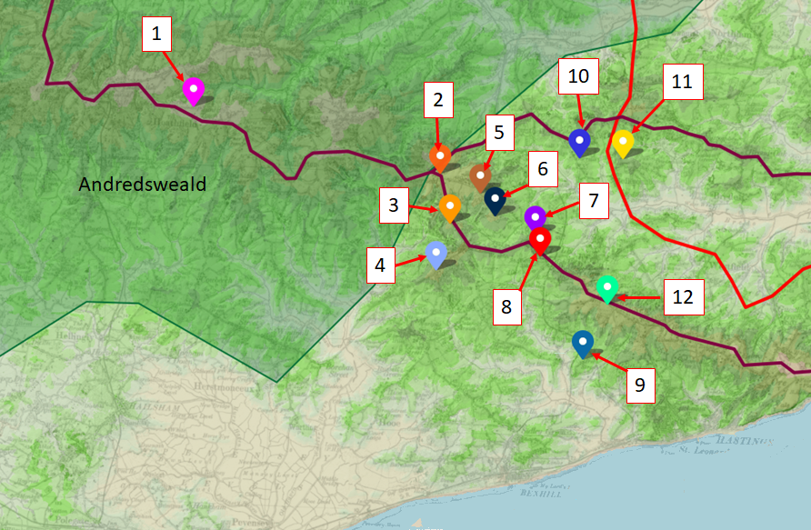
This map is a lidar map of the area, and shows the ridges in the area, the ridgeways described by Ivan D Margary in maroon, Roman Roads again as described by Margary in red. The different locations are numbered and Slaughter Common is number 1
| Detailed Lidar Map of the Area ▲ |
|---|
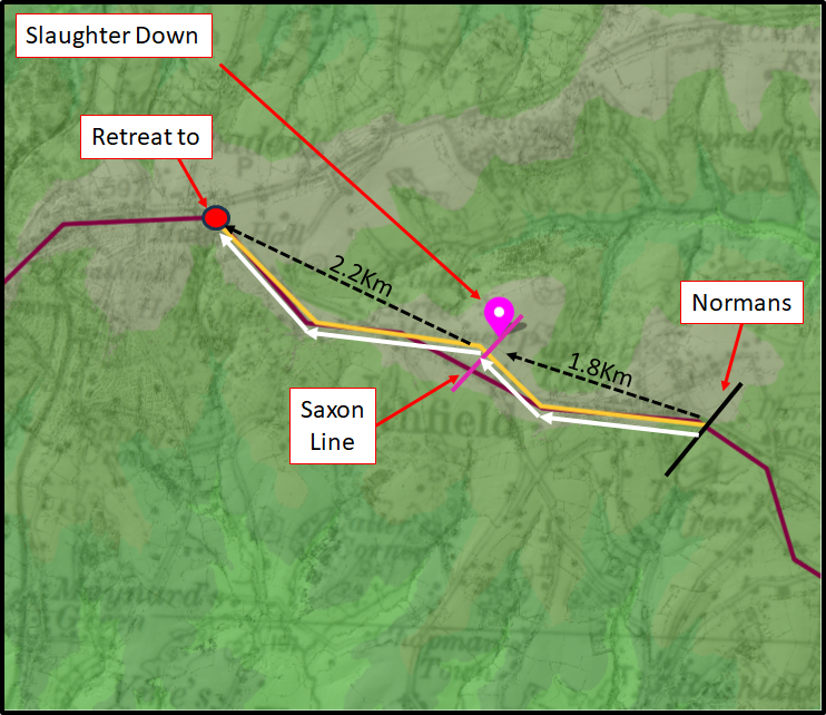
This map is a lidar map of the area, please click on the image for a larger version.
The land profile of the yellow line is shown in the following image .
| The land profile ▲ |
|---|
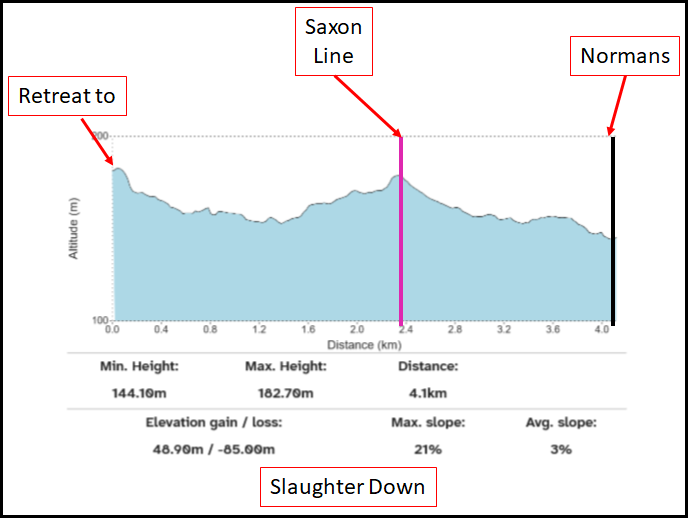
As you can see the land profile for the area is a gentle slope starting where the Normans would have to arrive from if they were based in Hastings, and carries on fairly flat until you get to Heathfield.
So with a maximum slope of 21% this site doesn't seem to reflect a steep hill, and the hill behind the saxons seems too gentle to until the final hill, furthermore this is 2.2 Km from the proposed battle site, which implies a long fighting retreat for men on foot which would seem unlikely if there were cavalry involved.
| 1. ✅The Haran Apuldran (Hoar Apple tree ?? ASC) ▲ |
|---|
|
This area could quite possibly be the area of the Haran Apuldran, please read Battle of Hastings 1066AD - The Hoar Apple tree to see if you agree. North Down at Heathfield sits at approximately 440 feet elevation on the ridgeway route from London to Lewes. The location fits perfectly as a strategic assembly point - high ground with good visibility, on a major route, at the edge of Andredsweald forest. Medieval deeds record 'Horeapeltre' in this area, strongly suggesting this was indeed the Anglo-Saxon Chronicle's 'haran apuldran.'
| | |
|---|
2. ✅ The Saxons were near a forest ▲ |
|---|
|
This area was inside the Forest of Andredsweald, and although there were heathland areas inside the forest, probably Heathfield and Frant, getting to these heathlands would mean that the armies had to march through forest where they could be easily ambushed. We also have information from the Domesday book that Dallington was in the Forest, this would mean that the Heathfield area must have also been inside the forest, even if it was open heathland. Please see our The Great Forest of Andredsweald - Anglo Saxon Chronicles for the position of the Forest Boundary from the Domesday book in 1087AD. Also if the troops were inside the forest then the visibility would be limited along with open ground big enough for a battle. Slaughter Common lies within the medieval bounds of Andredsweald as recorded in Domesday. While Heathfield itself may have been open heathland (hence the name), it would have been surrounded by dense oak forest. Any Norman approach from the coast would require passing through miles of forested terrain where ambush was a constant threat. The area meets the Carmen's description of forces emerging 'from wooded cover.'
| | |
|---|
3. ✅ Harold ascended a hill ▲ |
|---|
|
This is prior to the Battle and going up to North Down to muster would require Harold to ascend a hill, but this holds true for the majority of the sites, the hill up to North Down is a gentle slope. This site would require Harold to reach the Battlefield by taking the London - Lewes Roman road and cutting across the old ridgeways to Heathfield. Harold approaching from London via the Roman road would have ascended the gradual slope to North Down to reach the mustering point. However, this ascent is gentle (maximum 21% gradient) rather than the steep climb the Carmen describes for the battlefield position itself.
| | |
|---|
4. ✅ The Saxons were on a hill ▲ |
|---|
|
Slaughter Common is on a hill so this is true. Slaughter Common occupies elevated ground at approximately 350-370 feet. However, this elevation advantage is diminished by the gentle approach gradient - the Normans would not face the tactical disadvantage of charging a steep slope.
| | |
|---|
5. ❌ The Saxons were on level ground ▲ |
|---|
|
Slaughter Common is a gentle hill but it can't really be described as level. Henry of Huntingdon describes Harold drawing up his army 'on level ground.' While the top of Slaughter Common has relatively flat areas suitable for forming ranks, the overall topography is rolling rather than level. However, this contradiction with other chronicles may reflect Henry's distance from events - he was writing from Huntingdonshire 60+ years after the battle and likely never visited the site.
| | |
|---|
6. ❌ The Saxons fortify their position ▲ |
|---|
|
There is no evidence or even LiDAR traces to imply this is true, however this is not proof. Multiple chronicles describe significant fortifications: ditches, fosses, ramparts, and barriers constructed by Harold's forces. No archaeological evidence or LiDAR traces of such earthworks exist at Slaughter Common. While absence of evidence is not proof - the area may never have been surveyed with modern methods - the complete lack of any traces is notable. Additionally, the gentle slopes would require more extensive earthworks to create a defensive obstacle than a naturally steep position would need.
| | |
|---|
7. ✅ The terrain was rugged and uncultivated ▲ |
|---|
|
This is very likely as the area was probably Heathland as derived from the etymology of Heathfield. The Carmen describes 'rugged and uncultivated' terrain. Heathfield's name itself suggests open heathland - rough pasture unsuited to agriculture. This uncultivated character fits the Carmen's description and would also explain the lack of archaeological evidence, as rough heathland would have been subject to minimal plowing that might disturb battle debris.
| | |
|---|
8. ❌ The area was called Senlac ▲ |
|---|
|
Orderic Vitalis states the English 'took post at a place which was anciently called Senlac.' No place name resembling Senlac, Santlache, or any variant has been recorded in the Heathfield area. The etymology and location of Senlac remain debated, but no historical connection to Heathfield/Slaughter Common has been established. See our dedicated Senlac Hill page for detailed analysis of this place name and its possible meanings and locations.
| | |
|---|
9. ❌ The Battlefield was quite wide and not restricted ▲ |
|---|
|
Wace describes 'the plain wide' with space for large-scale maneuvers. While Slaughter Common has some open ground, the area is more restricted than Wace's description suggests. The heathland clearing would be surrounded by forest on most sides, limiting deployment options and making the broad cavalry maneuvers described in the chronicles difficult. For two armies of 7,000-15,000 men each to deploy in formation with room for cavalry squadrons to maneuver, pursue fleeing enemies, and conduct the feigned retreats described in multiple chronicles, a wider and more open battlefield would be required. The forest-enclosed nature of Slaughter Common constrains tactical options.
| | |
|---|
10. ❌ The Battle was 9 miles from Hastings ▲ |
|---|
|
Florence of Worcester clearly states the battle occurred 'at a place nine miles from Hastings.' Slaughter Common is approximately 12-13 miles from Hastings town center by the most direct routes - significantly exceeding this distance. Even accounting for medieval mile variations (1.1-1.5 modern statute miles) and uncertainty about the measurement point in Hastings (town center, castle, port, or Norman camp), the Heathfield location is too far north to satisfy Florence's specific measurement. The discrepancy of 3-4 miles is too large to be explained by measurement uncertainty alone.
| | |
|---|
11. ❌ The Norman camp was at the seaside ▲ |
|---|
|
The Carmen describes William returning to 'his coastal camp' or 'camp by the shore' after the battle. All sources place the Norman base at or near the coast. Slaughter Common is 12-13 miles inland - too far for the Normans to have marched from their coastal camp, fought an all-day battle, and returned to the coast the same day. The logistics of supply, communication, and security would make such a distant battlefield impractical when William had just landed and needed to maintain contact with his ships. The Norman fleet was their lifeline and line of retreat if the battle went badly. William would not venture so far inland in his first major engagement on English soil.
| | |
|---|
12. ❌ The Battle raged from the 3rd Hour ▲ |
|---|
|
The chronicles state the battle began at the third hour (approximately 09:46-11:19 GMT based on sunrise times) and lasted until nightfall (approximately 17:00 GMT). For a Slaughter Common battlefield, the Normans would need to march 12-13 miles from their coastal camp, arriving exhausted. At 2-2.5 mph with full armor and weapons, this represents a 5-6 hour march. Starting at first light (06:46 GMT), they could not arrive before noon - too late for a third-hour battle start. William would not position his army so far from his base that a morning march was impossible. The timeline simply does not work for a Heathfield battlefield.
| | |
|---|
13. ❌ William was initially on a hill ▲ |
|---|
|
Both the Battle Abbey Chronicles and Master Wace place William on a hill from which he could observe his forces. The Battle Abbey Chronicles state William 'arrived at a hill called Hechelande' and Wace writes 'The duke stood on a hill, where he could best see his men.' At Slaughter Common, there is no obvious elevated position south of the Saxon line from which William could command with clear views of the battlefield. The terrain slopes gradually upward from the coast, meaning William would be lower than Harold throughout - the opposite of the 'duke stood on a hill' description. No candidate for this command position has been identified in the Heathfield area.
| | |
|---|
14. ❌ The hill William was on was called Hecheland ▲ |
|---|
|
The Battle Abbey Chronicles name William's initial position as 'a hill called Hechelande, situated in the direction of Hastings.' No place name resembling Hecheland, Hechelande, or variants exists in the Heathfield area or on the route from Hastings to Slaughter Common. The name has not been identified anywhere in the region. Possible Old English interpretations include 'Hæcc-land' (land with a gate), 'Heah-land' (high land), or 'Hecche-land' (land with a hedge), but no modern place name preserves any of these forms in the Heathfield area. See our dedicated Hecheland page for detailed linguistic analysis and proposed locations elsewhere in the region.
| | |
|---|
15. ❌ The Normans advanced over a ridge ▲ |
|---|
|
Master Wace describes the Normans 'advancing over the ridge of a rising ground' as they approached the Saxon position. This suggests a distinct topographical feature - a ridge or crest - that the Norman army crossed before engaging Harold's forces. The terrain from the coast toward Heathfield is characterized by gradual continuous ascent rather than distinct ridges. While minor undulations exist, there is no prominent ridge feature that the Norman army would cross immediately before engaging at Slaughter Common. The topography lacks the dramatic terrain features described in the chronicles.
| | |
|---|
16. ❌ Behind the Normans was another hill ▲ |
|---|
|
Master Wace records that non-combatants (camp followers, priests, clerks) 'moved off towards a rising ground' and 'ascended a hill' behind the Norman lines to observe the battle safely. This indicates elevated ground to the rear of William's position. South of Slaughter Common (toward the coast), the terrain generally descends rather than rises. There is no obvious elevated ground behind where the Norman position would be that could serve as a safe observation point for non-combatants. The landscape does not provide the rear hill Wace describes - instead, the ground falls away toward the coast.
| | |
|---|
17. ❌ There was a fosse between the forces ▲ |
|---|
|
Multiple chronicles describe fosses, ditches, and trenches - some natural, some constructed by Harold's forces. Master Wace describes the position 'surrounded by a good fosse' with three guarded entrances. Henry of Huntingdon mentions 'a deep trench, treacherously covered' into which Normans fell during pursuit. The Battle Abbey Chronicles describe 'a certain dreadful precipice' that caused heavy casualties. No such features have been identified at Slaughter Common through field survey or LiDAR analysis. The gently rolling terrain lacks the dramatic topographical features these accounts describe. While it's possible Harold's forces constructed temporary earthworks that have since been plowed away, the complete absence of any natural ditches, ravines, or steep-sided features is notable. For more details on this landscape feature see our Evidence for the Malfosse page.
| | |
|---|
18. ❌ There was a steep slope up to the Saxons ▲ |
|---|
|
The Carmen explicitly describes William's forces having to charge uphill to reach the Saxon position: 'The Duke below fearing mastery from the height... boldly approaches the steep slope. They gather in tight formation to charge the slope for slaughter.' The maximum gradient approaching Slaughter Common is only 21% over a distance of approximately 2.2 km. This represents a gentle, gradual rise unsuitable for creating significant tactical disadvantage to attacking cavalry. The terrain profile shows steady ascent rather than the sharp, steep slope that would give defenders a commanding advantage and make Norman cavalry charges 'for slaughter' particularly difficult. The topography does not match the Carmen's emphasis on steepness. A truly steep slope would be 30-40% or greater - the kind of gradient where cavalry would struggle to maintain formation and momentum. The gentle 21% slope at Slaughter Common would slow cavalry somewhat but would not create the defensive advantage the Carmen describes.
| | |
|---|
19. ✅ Behind the Saxons was another hill ▲ |
|---|
|
Master Wace describes the English retreat: 'The English fell back upon a rising ground, and the Normans followed them across the valley.' This indicates that behind Harold's position there was lower ground (a valley) followed by another hill to which the routed Saxons retreated. At Slaughter Common, the terrain behind the proposed Saxon position drops down then continues to rise gradually toward Heathfield town (reaching 440+ feet at North Down).
However, the land profile shows the proposed retreat direction would about 2.2 km into the valley then up to North Down - an implausibly long fighting retreat for men on foot pursued by cavalry. Routed infantry cannot maintain a fighting withdrawal uphill for over two kilometers while being harried by mounted warriors.
| | |
|---|
20. ❌ The sea was behind the Normans ▲ |
|---|
|
The Carmen states 'The sea is behind, back by sea is the way to return' and describes William after the battle returning 'to his seaside camp.' This makes clear that the Norman army had the sea at their backs during the battle - their line of retreat and their ships were behind them to the south. At Slaughter Common, the Normans would have the forest of Andredsweald and 12-13 miles of contested territory behind them, not the sea. Their line of retreat would not be to the coast but back through miles of potentially hostile woodland where ambush was a constant threat. This contradicts the Carmen's clear statement that the Norman army had the sea at their backs, with their ships and supply base behind them to the south. The geographical relationship between battlefield and coast does not match the source material. William's strategic position required direct access to his fleet - he could not afford to be cut off from his ships by distance and forest.
| | |
|---|
21. ❌ Fleeing Saxons were killed when a bridge collapsed ▲ |
|---|
|
Master Wace describes fleeing Saxons attempting to cross a bridge during the retreat: 'The press was great to cross the bridge, and the river beneath it was deep; so that the bridge broke under the throng, and many fell into the water.' This describes a substantial river crossing with a bridge on the Saxon retreat route. The retreat from Slaughter Common toward London would follow the ridgeway northward through Heathfield - a route that does not cross any major river requiring a bridge. The nearest significant river crossings would be miles away from the logical retreat path. No candidate river and bridge location has been identified that fits Wace's account in connection with a Slaughter Common battlefield. The described incident requires a deep river with a bridge substantial enough to carry traffic but weak enough to collapse under the press of panicked men. Such a feature would be on a main retreat route, not a minor detour. No such location exists on the Heathfield-to-London route. See our dedicated Bridge Collapse page for detailed analysis of possible locations for this incident.
| | |
|---|
Analysis Summary ▲ |
|---|
|
Slaughter Common/Heathfield successfully satisfies only 6 of the 21 landscape criteria from the chronicles: ✅ Satisfied (6): - 1. The Haran Apuldran (Hoar Apple Tree) - excellent fit as mustering point
- 2. Near a forest - within Andredsweald forest bounds
- 3. Harold ascended a hill - gentle ascent to North Down
- 4. Saxons on a hill - elevated ground at 350-370 feet
- 7. Rugged and uncultivated - heathland terrain
- (Item 5 'level ground' is contradictory among sources)
❌ Not Satisfied (15): - 6. Saxons fortify their position - no evidence
- 8. The area was called Senlac - no name connection
- 9. Battlefield was wide and not restricted - too constrained by forest
- 10. Battle was 9 miles from Hastings - actually 12-13 miles
- 11. Norman camp at seaside - too far inland
- 12. Battle from 3rd hour - timeline impossible with 5-6 hour march
- 13. William on a hill - no suitable command position identified
- 14. Hill called Hecheland - name not found in area
- 15. Normans advanced over ridge - no distinct ridge feature
- 16. Hill behind Normans - terrain descends, not rises
- 17. Fosse between forces - no features identified
- 18. Steep slope to Saxons - only 21% gentle gradient
- 19. Hill behind Saxons - terrain matches structurally but 2.2km fighting retreat implausible
- 20. Sea behind Normans - forest and 12 miles behind them instead
- 21. Bridge collapsed - no major river crossing on retreat route
Conclusion: The evidence strongly supports Heathfield/North Down as Harold's mustering point (the Hoar Apple Tree location mentioned in the Anglo-Saxon Chronicle), but Slaughter Common does not match the detailed landscape descriptions of the actual battlefield location. The site is too far inland (12-13 miles vs 9 miles stated), lacks steep slopes (21% vs 'steep slope' described), shows no evidence of fortifications or ditches, and fails to provide the complex topography that multiple independent chronicles describe: multiple hills with Norman and Saxon positions, valleys, ridges, fosses, a retreat route with river crossing, and proximity to the coast. The most likely interpretation is that Harold mustered his forces at the Hoar Apple Tree (North Down, Heathfield) as the Anglo-Saxon Chronicle states, but then marched south toward the coast to engage William's forces at a location closer to the Norman base - a site yet to be definitively identified but which must satisfy far more of the 21 chronicle criteria than Slaughter Common does.
|
|
|
;)
)
)
)


