|
Battle of Hastings 1066AD
Location - Site 2 - Netherfield |
|---|
|
Who suggested this site and where is it ? ▲ |
|---|
WARNING: This site is proposed by Simon, the author of this site, so although biased i still hope to be analytical in my approach to all sites.
|
Site Concept ? ▲ |
|---|
This site is at the area of Darvell Down (Netherfield) where the Battle to Heathfield ridgeway (nowadays known as the B2096) joins with the Netherfield Road.
The great Forest of Andredsweald had been cut back from Hastings to this area by 1086AD and this can be shown by plotting the Domesday Villages. So this makes the area very close to the Forest edge.
Another reason is that it was on one of the ridgeways out of the old Kingdom of Hastings and is on a junction where the Rye Ridgeway joins with the Battle Ridgeway. This in turn provides access to the only two routes out of the area. The first is via Heathfield and Crowborough to the Old Roman road recorded by Margary as M14, the second leads down the Rye Ridgeway to the second Roman road which goes from Hastings to Rochester via Bodiam again recorded by Margary as M13.
The area is on top of a ridge with steep valleys either side and has the steepest slope out of all the suggested sites, and also has a hill behind.
|
Overall map of the Area ▲ |
|---|
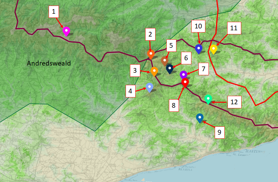
This map is a lidar map of the area, and shows the ridges in the area, the ridgeways described by Ivan D Margary in maroon, Roman Roads again as described by Margary in red. The different locations are numbered and Slaughter Common is number 1
|
Detailed Lidar Map of the Area ▲ |
|---|
 This map is a lidar map of the area, please click on the image for a larger version.
The land profile of the yellow line is shown in the following image .
This map is a lidar map of the area, please click on the image for a larger version.
The land profile of the yellow line is shown in the following image .
|
The land profile ▲ |
|---|
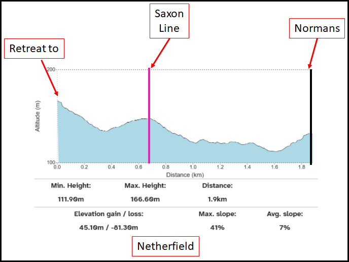
As you can see the land profile for the area has quite a steep profile, and has both a hill for William, a hill for the defenses and finally another hill where Harold is killed.
This profile shows the steepest slope out of all the sites of 41% for the Normans to attack up and a plain to attack over and another to Harold's hill, with the final distance only about 0.6Km which would allow the Saxons to make a fighting retreat and then are cut down.
The
|
| |
|---|
1. ❌ The Haran Apuldran (Hoar Apple tree ?? ASC) ▲ |
|---|
|
The Anglo-Saxon Chronicle states Harold mustered at the 'haran apuldran' (Hoar Apple Tree). The Netherfield theory places this at Heathfield/North Down, approximately 5 miles north of the proposed battlefield. However, Netherfield itself is not the Hoar Apple Tree location - it is proposed as the battlefield to which Harold marched after mustering. The site therefore does not directly satisfy this criterion, though it is consistent with Harold having mustered at Heathfield and then moved south to Netherfield. For detailed analysis of the Hoar Apple Tree location, see our Hoar Apple Tree page.
|
| |
|---|
2. ✅ The Saxons were near a forest ▲ |
|---|
|
Netherfield sits at the southern edge of the Forest of Andredsweald, as shown in Domesday Book records and landscape reconstructions. The Carmen describes the English emerging 'from the forest' and 'from wooded cover,' which fits the Netherfield location perfectly. The forest edge would have provided timber for constructing defensive works including palisades and stakes. The proximity to the forest also matches the Carmen's description of 'a wooded hill, neighbouring the valley.' Please see our The Great Forest of Andredsweald - Anglo Saxon Chronicles for the position of the Forest Boundary from the Domesday book in 1087AD.
|
| |
|---|
3. ✅ Harold ascended a hill ▲ |
|---|
|
The approach to the Netherfield ridge from the Heathfield muster point involves ascending from approximately 120 feet elevation from the ridgeway crossing Penhurst lane to the Netherfield ridge. While the overall route follows the ridgeway, there are variations in elevation that would involve some steep ascent to reach the final defensive position.
The Carmen states 'The king ascended the summit that he might wage war in the midst of his army,' which could describe Harold taking position on the Netherfield ridge. However, this description could apply to multiple sites along the ridgeway system.
|
| |
|---|
4. ✅ The Saxons were on a hill ▲ |
|---|
|
Netherfield occupies a ridge position along the ancient ridgeway from Hastings to London. The location is on elevated ground, satisfying the multiple chronicle references to the Saxons being positioned on a hill. The Carmen, Battle Abbey Chronicles, Master Wace, and the Bayeux Tapestry all describe the English on elevated ground. The Netherfield ridge provides such a position with commanding views of approaches from the south and east.
|
| |
|---|
5. ✅ The Saxons were on level ground ▲ |
|---|
|
Henry of Huntingdon describes Harold drawing up his army 'on level ground.' While Netherfield is on a ridge, the ridge top has relatively level areas where an army could form up in ranks and create a defensive line. This apparent contradiction - being both on a hill and on level ground - is resolved if the position featured a hill with a relatively flat top or plateau, which the Netherfield ridge provides. The level summit would allow the shield wall to form effectively while the slopes provide defensive advantage.
|
| |
|---|
6. ✅ The Saxons fortify their position ▲ |
|---|
|
This is the central claim of the Netherfield theory. Multiple chronicles describe fortifications: Master Wace describes the position 'surrounded by a good fosse' with three guarded entrances, and mentions the English building 'a fence before them with their shields, and with ash and other wood.'
Florence of Worcester states the English 'had built a fort' at the location. Henry of Huntingdon mentions 'a deep trench, treacherously covered.' The Battle Abbey Chronicles describe 'a certain dreadful precipice' between the armies.
The Netherfield theory proposes that Harold's forces constructed field fortifications on 13 October: a timber palisade, a ditch dug in front, the spoil backfilled against the palisade to create a raised fighting bank, and sharpened stakes placed in and before the ditch. This construction sequence is archaeologically attested in other defensive works.
However, no physical evidence of such fortifications has been found at Netherfield. As with all proposed sites, the lack of archaeological evidence remains a challenge. The defences, if they existed, would have been temporary field fortifications that could have been plowed away or eroded over the centuries, however traces of lowered ground should be visible on lidar and there are what looks like a ditch crossing the main road just lower than the top of the ridge.
|
| |
|---|
7. ✅ The terrain was rugged and uncultivated ▲ |
|---|
|
The Carmen describes 'rugged and uncultivated' terrain. The Wealden ridge at Netherfield at the forest edge would likely have been heathland or rough pasture rather than cultivated agricultural land in 1066. This uncultivated character fits the Carmen's description and, like other sites, would help explain the lack of archaeological evidence - rough heathland would have been subject to minimal plowing that might disturb and scatter battle debris over the centuries.
|
| |
|---|
8. ❓ The area was called Senlac ▲ |
|---|
|
Orderic Vitalis states the English 'took post at a place which was anciently called Senlac.' The Netherfield theory proposes that 'Senlac' derives from 'isen lacu' meaning 'Iron Lake,' and notes that Beech Farm near Netherfield was a Domesday iron-working site. This interpretation is speculative. The etymology of 'Senlac' remains debated, with multiple proposed meanings including 'sand lake,' 'sea lake,' or various other interpretations. No place name resembling Senlac has been definitively identified in the Netherfield area, and the 'Iron Lake' theory, while creative, lacks strong linguistic or historical support. See our dedicated Senlac Hill page for detailed analysis of the various theories about this place name.
|
| |
|---|
9. ✅ The Battlefield was quite wide and not restricted ▲ |
|---|
|
Master Wace describes 'the plain wide' with space for large-scale maneuvers. The Netherfield ridge provides ample width for deploying large armies - significantly more than some alternative sites. The ridge location would allow both armies to deploy in formation with room for cavalry squadrons to maneuver, pursue fleeing enemies, and conduct the feigned retreats described in multiple chronicles. The ridge top is sufficiently broad to accommodate the thousands of men engaged on each side.
|
| |
|---|
10. ✅ The Battle was 9 miles from Hastings ▲ |
|---|
|
Florence of Worcester states the battle occurred 'at a place nine miles from Hastings.' Netherfield is approximately 8-9 miles from Hastings town center, closely matching this measurement. The Netherfield theory also identifies the Norman camp at Bexhill (rather than Hastings itself), which is approximately 7-8 miles from Netherfield. Accounting for medieval mile variations (1.1-1.5 modern statute miles) and uncertainty about the exact measurement point, Netherfield fits Florence's distance reasonably well - better than sites significantly further north like Heathfield (12-13 miles).
|
| |
|---|
11. ✅ The Norman camp was at the seaside ▲ |
|---|
|
The Carmen describes William returning to 'his coastal camp' or 'camp by the shore' after the battle. The Netherfield theory places the Norman camp at Bexhill on the coast, based on Domesday evidence of village destruction patterns suggesting Norman foraging routes and the location of William's pre-fabricated fort. Bexhill is approximately 7-8 miles from Netherfield - a manageable distance for the Norman army to march in one morning, fight an all-day battle, and potentially return to camp. This is far more plausible than sites 12-13 miles inland like Heathfield. The coastal camp location satisfies the Carmen's descriptions and provides William with the necessary proximity to his ships and supply base.
|
| |
|---|
12. ✅ The Battle raged from the 3rd Hour ▲ |
|---|
|
The chronicles state the battle began at the third hour (approximately 09:46-11:19 GMT based on sunrise times at 06:46 GMT on 14 October) and lasted until nightfall (approximately 17:00 GMT). The Netherfield theory calculates that a dawn march from Bexhill to Netherfield along the ridgeway would take approximately 3 hours at 2-2.5 mph. Starting at first light (06:46 GMT), the Norman army could arrive at Netherfield around 09:45-10:00 GMT, which fits the 'third hour' start time. The 7-8 mile distance from Bexhill makes a morning march feasible, unlike more distant sites. The battle could then rage from approximately 10:00 GMT until nightfall at 17:00 GMT - a 7-hour engagement consistent with the chronicles' descriptions of an all-day battle.
|
| |
|---|
13. ✅ William was initially on a hill ▲ |
|---|
|
Both the Battle Abbey Chronicles and Master Wace place William on a hill from which he could observe his forces. The Netherfield theory identifies William's observation position as the high ground near Beech Wood on the Kame Hithe road, from which he could view the English position on the Netherfield ridge before advancing.
The Beech High wood ridge is south of Netherfield on the approach route from Bexhill, providing an elevated position from which William could observe the battlefield and the English defences before committing his forces to the attack.
|
| |
|---|
14. ❓ The hill William was on was called Hecheland ▲ |
|---|
|
The Battle Abbey Chronicles name William's initial position as 'a hill called Hechelande, situated in the direction of Hastings. The Netherfield theory proposes that Hecheland was a generic term for high ground , and not specifically the Telham ridge.
The Beech Wood Hill was a second patch of high ground in the Abbey Lands south of Netherfield on the approach route from Bexhill/Hastings.
The Abbey Chronicles describe Hecheland as the land towards Hastings
See our dedicated Hecheland page for detailed analysis of possible locations and etymologies.
|
| |
|---|
15. ✅ The Normans advanced over a ridge ▲ |
|---|
|
Master Wace describes the Normans 'advancing over the ridge of a rising ground' as they approached the Saxon position. The ridgeway route from Bexhill via Telham to Netherfield follows high ground with several ridge features.
Advancing from the Beeh Wood Hill toward Netherfield, the Norman army would cross the ridge before advancing into the 'plain' before engaging the English forces. The topography fits Wace's description of approaching over elevated ground.
|
| |
|---|
16. ✅ Behind the Normans was another hill ▲ |
|---|
|
Master Wace records that non-combatants (camp followers, priests, clerks) 'moved off towards a rising ground' and 'ascended a hill' behind the Norman lines to observe the battle safely. Behind the Norman position approaching Netherfield from the south would be the Telham ridge (proposed Hecheland) and terrain sloping back toward Bexhill. This elevated ground behind the Norman lines could provide observation points for non-combatants, matching Wace's description.
|
| |
|---|
17. ✅ There was a fosse between the forces ▲ |
|---|
|
Multiple chronicles describe the Malfosse - the ditch or fosse between the armies. Master Wace describes the position 'surrounded by a good fosse' with three guarded entrances. Henry of Huntingdon mentions 'a deep trench, treacherously covered' into which Normans fell during pursuit. The Battle Abbey Chronicles describe 'a certain dreadful precipice' that caused heavy casualties. The Netherfield theory proposes that Harold's forces dug a defensive ditch in front of their palisade on 13 October, backfilling the spoil against the timber wall to create a raised fighting bank. During the battle, attacking Normans and pursuing English would have fallen into this concealed ditch, causing the mass casualties described in multiple sources. The Bayeux Tapestry's depiction of horses falling and men tumbling is interpreted by the Netherfield theory as evidence of this ditch and the sharpened stakes (caltrops) placed within it. However, no physical evidence of such a ditch has been found at Netherfield. The fosse remains a theoretical reconstruction based on the chronicles rather than archaeological discovery. For more details on this landscape feature see our Evidence for the Malfosse page.
|
| |
|---|
18. ✅ There was a steep slope up to the Saxons ▲ |
|---|
|
The Carmen explicitly describes William's forces having to charge uphill to reach the Saxon position: 'The Duke below fearing mastery from the height... boldly approaches the steep slope. They gather in tight formation to charge the slope for slaughter.'
The Netherfield ridge has slopes on its southern and eastern flanks facing the Norman approach from Bexhill. The gradient of the approach to this area is 41% which is a steep hill and so they they match the Carmen's description of a 'steep slope.'
The raised bank created by backfilling ditch spoil against the palisade (as proposed in the Netherfield theory) would further increase the effective height and steepness that attacking Normans would face, potentially explaining the Carmen's emphasis on the difficulty of charging the slope.
|
| |
|---|
19. ✅ Behind the Saxons was another hill ▲ |
|---|
|
Master Wace describes the English retreat: 'The English fell back upon a rising ground, and the Normans followed them across the valley.' This indicates that behind Harold's position there was lower ground (a valley) followed by another hill to which the routed Saxons retreated.
North of Netherfield, the ground rises again toward the Netherfield Rye ridgeway which leads past Mountfield to join Margary's road M13 to Rochester. This provides a potential fallback position or retreat route as Wace describes, with the retreating English moving back along the ridgeway toward higher ground to the north.
The topography provides the valley-then-hill sequence that Wace mentions please see the topography diagram.
|
| |
|---|
20. ✅ The sea was behind the Normans ▲ |
|---|
|
The Carmen states 'The sea is behind, back by sea is the way to return' and describes William after the battle returning 'to his seaside camp.' This makes clear that the Norman army had the sea at their backs during the battle. With the English positioned on the Netherfield ridge facing south toward the approaching Normans from Bexhill, the Norman army would indeed have the sea at their backs - their camp, supply base, and ships all lay to the south along the coast. The 7-8 mile distance from Netherfield to the coastal camp at Bexhill is manageable, allowing William to maintain communication with his fleet while still engaging the English inland. This satisfies the Carmen's geographical description far better than sites 12-13 miles inland.
|
| |
|---|
21. ✅ Fleeing Saxons were killed when a bridge collapsed ▲ |
|---|
|
Master Wace describes fleeing Saxons attempting to cross a bridge during the retreat: 'The press was great to cross the bridge, and the river beneath it was deep; so that the bridge broke under the throng, and many fell into the water.'
The Netherfield theory proposes that this bridge was at Bodiam, approximately 5 miles east-northeast of Netherfield. Bodiam sits on the River Rother, which in 1066 was a deep tidal inlet rather than the narrow river it is today.
The theory suggests that fleeing English forces, retreating along the ridgeway from Netherfield, would naturally head toward the Rother crossing at Bodiam on the escape route back toward London and the interior. The bridge over the tidal Rother would be substantial, and the deep tidal waters would be fatal to men in armor.
This identification is plausible and fits the geographical logic of an escape route from Netherfield, though it requires accepting that the English retreat went east through Mountfield to join the old Roman road M13 at Cripps Corner then toward Bodiam rather than north west toward Heathfield (the original muster point).
See our dedicated Bridge Collapse page for detailed analysis of possible locations for this incident.
|
| |
|---|
Analysis Summary ▲ |
|---|
|
Netherfield satisfies substantially more of the 21 landscape criteria than Heathfield/Slaughter Common: ✅ Clearly Satisfied (15): - 2. Near a forest - at Andredsweald edge
- 3. Harold ascended a hill - approach to ridge position
- 4. Saxons on a hill - ridge location
- 5. Saxons on level ground - ridge top plateau
- 6. Saxons fortify position - proposed field fortifications (no physical evidence)
- 7. Rugged and uncultivated - heathland at forest edge
- 9. Battlefield wide and not restricted - ridge provides width
- 10. Battle 9 miles from Hastings - 8-9 miles matches well
- 11. Norman camp at seaside - Bexhill 7-8 miles south
- 12. Battle from 3rd hour - 3-hour march from Bexhill fits timeline
- 15. Normans advanced over ridge - ridgeway approach
- 16. Hill behind Normans - Telham ridge to south
- 17. Fosse between forces - proposed Malfosse ditch (no physical evidence)
- 19. Hill behind Saxons - Heathfield ridge to north
- 20. Sea behind Normans - coast 7-8 miles south
✅ Probably Satisfied (3): - 13. William on a hill - proposed Telham/Hecheland position
- 18. Steep slope to Saxons - ridge slopes plus raised bank
- 21. Bridge collapsed - proposed Bodiam location
❓ Uncertain (2): - 8. Called Senlac - speculative 'Iron Lake' etymology
- 14. Hill called Hecheland - Telham proposed but no place-name evidence
❌ Not Satisfied (1): - 1. The Haran Apuldran - this is proposed as Heathfield muster point, not Netherfield battlefield
Conclusion: Netherfield presents a significantly stronger case than Heathfield/Slaughter Common, satisfying approximately 18-20 of the 21 criteria depending on how speculative interpretations are assessed. The site's main strengths are: - Distance from Hastings/Bexhill (8-9 miles) fits Florence's measurement
- Timeline works: 3-hour dawn march allows third-hour battle start
- At forest edge on ridgeway route
- Reasonable width for large engagement
- Logical geography for proposed Bexhill camp, Telham observation point, Bodiam bridge
- Better fits Norman tactical needs (closer to coastal base than Heathfield)
The site's main weaknesses are: - No archaeological evidence for fortifications or ditches
- Senlac etymology ('Iron Lake') is speculative
- Hecheland identification at Telham lacks place-name support
- Relies heavily on reconstructed field fortifications with no physical traces
- The Bayeux Tapestry interpretation (stakes causing 'flying horses') is contested
The Netherfield theory offers a coherent and detailed reconstruction that accounts for most chronicle evidence and geographical constraints. However, like all proposed battlefield sites, it lacks the definitive archaeological evidence that would confirm the location beyond doubt. The case rests on the convergence of multiple lines of circumstantial evidence rather than physical proof.
|
;)
)
)
)


