| Gypsum Deposits and Mining near Mountfield |
|---|
| | |
|---|
What is Gypsum ? ▲ |
|---|
Gypsum is a soft Calcium sulphate mineral (CaSO4.2H2O)) used globally in construction for plaster and drywall (plasterboard), as a soil conditioner to improve drainage and reduce sodium, and in various other products like cement, chalk, and even some paints.
It's a common evaporite mineral, forming in sedimentary layers, and can be mined naturally or produced synthetically as a byproduct of industrial processes, providing essential calcium and sulphur for plants and soil structure
| An Accidental Founding ▲ |
|---|
In 1872, geologists drilling in search of coal - part of the ambitious "Sub-Wealden Exploration" - struck something entirely different: a thick bed of high-quality gypsum. Recognising its value for plaster and agriculture, investors formed The Sub-Wealden Gypsum Company Ltd. in 1876, sinking the first proper mine in Limekiln Wood, Mountfield.
The operation quickly became a local mainstay. A dedicated railway link to the Hastings to London mainline fuelled its growth, with production and workforce expanding steadily for decades, particularly in the post-World War II building boom.
| The Twin-Mine System ▲ |
|---|
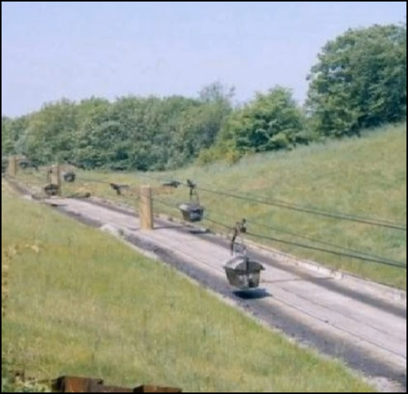 To meet rising demand, a major expansion unfolded in the early 1950s. A new, larger mine was opened at Brightling, a few miles west. This created a unique dual-site operation: gypsum was extracted at Brightling and then transported over three miles to the processing plant at Mountfield via a dramatic aerial ropeway—a bucket cableway that became a distinctive feature of the local landscape for a generation.
Please Note:
This photo is part photo from a video of old photos of Mountfield Gypsum Mines by Kevin Burchett, this is available on YouTube either by clicking the image or the following link YouTube - Kevin Burchett.
| | |
|---|
Peak, Transition, and Specialisation ▲ |
|---|
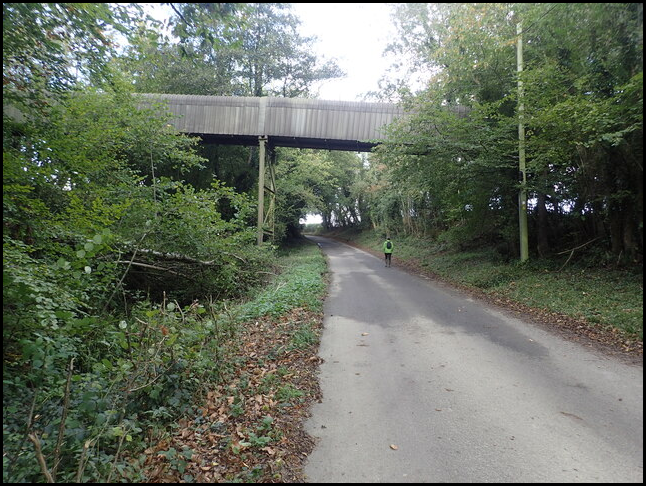 The mines hit their production peak in the 1970s and 80s, yielding nearly one million tonnes annually, primarily for the plasterboard industry. A significant modernisation came in 1989 when the aerial ropeway was replaced by a 4.7-kilometre enclosed conveyor belt, partially buried to minimise visual impact. Shortly after, the original Mountfield mine closed between 1990 and 1993 due to exhaustion of the gypsum seam, consolidating all extraction at the Brightling site.
The industry faced a seismic shift in the 1990s with the rise of Flue Gas Desulphurisation (FGD) gypsum, a synthetic by-product from coal-fired power stations that largely replaced natural gypsum in plasterboard. In response, the Brightling mine successfully pivoted to a specialised niche, now producing "cement rock" - a blend used as a vital set retarder in cement manufacturing.
Please Note:
The photo shows the Gypsum Mine conveyor over Hollingrove Road, taken Sunday, 24 October, 2021
© Marathon (cc-by-sa/2.0) geograph.org.uk/p/7001672 please click on the image for the original
| The Modern Legacy ▲ |
|---|
Today, the Brightling mine, operated by British Gypsum (part of Saint-Gobain), is a study in streamlined, specialised industry. Operating at roughly 10% of its historic capacity, it produces about 75,000 tonnes per year with a small, tight-knit team of just 17 people on day shifts.
Despite the smaller scale, its importance endures. It remains a strategic national asset with an estimated 20-30 years of reserves, and an application is pending to extend operations for a further 25 years. The mine boasts an exceptional safety record of over 14 years without a lost-time injury and maintains strong community links in Mountfield, supporting local projects.
From an accidental discovery in the Victorian era to a resilient specialist in the 21st century, the gypsum mines near Robertsbridge have quietly shaped both the local landscape and British industry for 150 years.
| Map of East Sussex Mineral Resources ▲ |
|---|
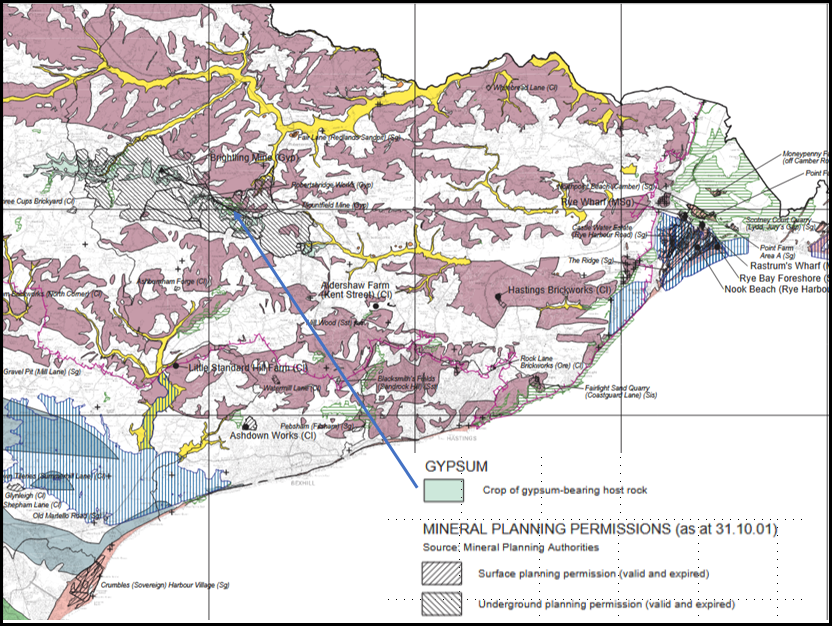
The source for all our maps is derived from:
(NORA) is the Institutional Repository for research publications and outcomes of staff at the British Antarctic Survey, British Geological Survey, National Oceanography Centre, and UK Centre for Ecology & Hydrology. https://nora.nerc.ac.uk/
| Map of Mineral Resources near Mountfield ▲ |
|---|
Please click on the image to open this map in a pop up window
This image is derived from https://nora.nerc.ac.uk/id/eprint/535166/1/eastSussexMap.pdf which shows mineral deposits in East Sussex.
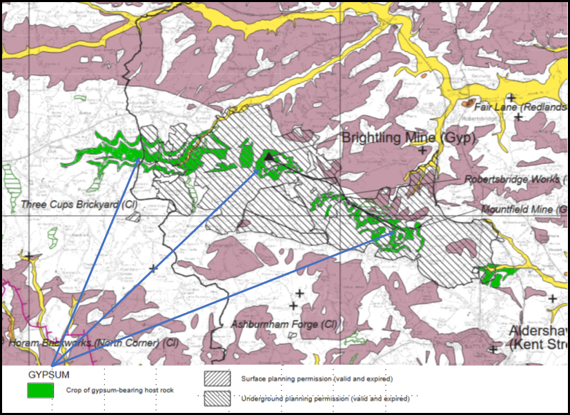
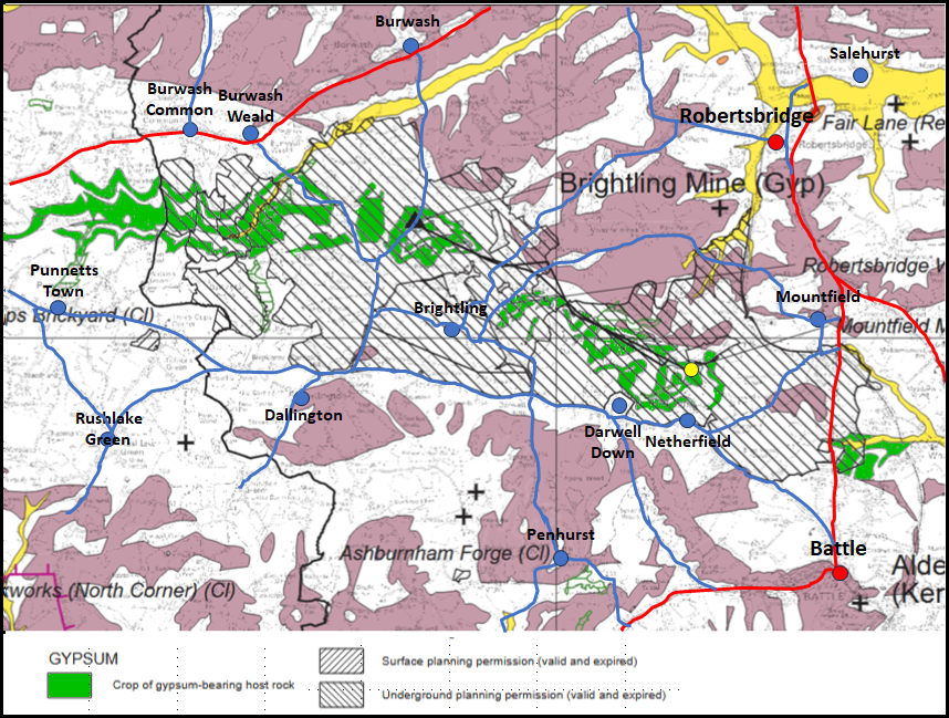
| Detailed Map of Mineral Resources near Mountfield ▲ |
|---|
Please click on the image to open a larger version of this map
This image is derived from https://nora.nerc.ac.uk/id/eprint/535166/1/eastSussexMap.pdf which shows mineral deposits in East Sussex.
This map shows a close up of the area with local roads and Villages shown, so the extent of the Gypsum deposits and possible mining areas can be seen.
| Mine Background from East Sussex County Council ▲ |
|---|
This is from the East Sussex County Council website East Sussex County Council
In 1876 a deep borehole was constructed on land to the southwest of the village of Mountfield.
It was drilled following agreement by a group of geologists, at the Brighton meeting of the British Association for the Advancement of Science to investigate the strata beneath the oldest exposed rocks in southeast England.
The discovery of 4 seams of gypsum in the Upper Jurassic Purbeck Limestone Formation led to the establishment of the Sub Wealden Gypsum Company Limited which is now part of British Gypsum owned by the
French multinational Saint-Gobain SA.
| Mine Background from the Mountfield Parish Website ▲ |
|---|
The following text is from Mountfield Parish Website
The discovery of gypsum (calcium sulphate) in Mountfield in 1872 came about by chance, the target of borings was coal. In its natural state gypsum is a rock found in seams, which are several feet thick and crushed into powder, in fact it is mined in a similar way to coal.
The Sub-Wealden Gypsum Company Limited was formed on 10th May 1876 and mining started with the sinking of a shaft in Limekiln Wood. Progress was initially slow because of the isolated position, until a railway link had been constructed to the main line at Robertsbridge. Gypsum mining then developed into the largest industry in the area and gypsum continues to be in great demand by the construction industry to make plaster and plasterboard.
| Mine Background from Battle & District Historical Society ▲ |
|---|
The following text is from Battle & District Historical Society - Gypsum
GYPSUM
The 1870s provided the first source of employment in the Battle area that was not
concerned with agriculture, its servicing and its products, or serving the comfortably-off, or
practising a profession. In 1876 the gypsum mine opened at Mountfield and quickly became
a major employer at a time when agriculture was beginning to enter a long depression
|
|
|
;)
)
)


